Showing posts with label vws. Show all posts
Saturday, September 24, 2011
Good Morning 40's
BRRRRRR:
We started Saturday morning out at 45.5°...with foggy skies, see this morning's webcam shot from our Emergency Management Agency. Typically, that shot is shows the landscape and buildings in our downtown area of Cookeville. This is our coolest morning start since May 17th.
TODAY'S FORECAST:
The fog will burn off later this morning and we'll go all the way up to 75° today under sunny skies!
SUNDAY THROUGH NEXT WEEK:
Rain chances move back into our forecast for Sunday after a low tonight of 51° under an increasingly cloudy sky. Just a 20% chance of rain Sunday, high 80° with a 50% chance for rain Sunday night, low 62° and showers likely (60%) on Monday, high 76°. After Monday, I believe we'll see an extended, rain-free period of weather for most all of next week with highs in the upper 70's to low 80's.
*Latest Local Forecast*
Cookeville's Daily Almanac
Our morning low: 45.5°
Yesterday's high: 67.0° (afternoon high was just 64.0°)
Yesterday's low: 48.9°
Last Year: 90.3° and 69.9°
Normal High: 78°
Normal Low: 53°
Records: 94° in 2007 and 33° in 1928
Rainfall Report
24-hour precip total: .23"
Sept. monthly precip total: 7.22"
2011 annual precip total: 54.94"
3.45" of rain fell on this date in 1975
Wednesday, July 14, 2010
Hot Weather Returns
HEAT ADVISORY WEST TN:
The hot weather is making it's return to Middle TN as temperatures here in Cookeville are expected to top 90° this afternoon. Look for continuing highs in the 90's each day through the end of this week. Rain possibilities come back late Friday and into the weekend. Our friends in West TN are under a Heat Advisory through tomorrow. See post from Erik at Memphis Weather!
THIS WEEK'S RAINS:
Check out the graphic below showing the last 3 days worth of rains. It sure helped to break what we were beginning to consider a new drought phase.
The hot weather is making it's return to Middle TN as temperatures here in Cookeville are expected to top 90° this afternoon. Look for continuing highs in the 90's each day through the end of this week. Rain possibilities come back late Friday and into the weekend. Our friends in West TN are under a Heat Advisory through tomorrow. See post from Erik at Memphis Weather!
THIS WEEK'S RAINS:
Check out the graphic below showing the last 3 days worth of rains. It sure helped to break what we were beginning to consider a new drought phase.
| At just after 8 am, it is going to be a hot one. Note 'heat index' |
Cookeville's Daily Almanac
This Morning's low: 67.8°
Rain, last 24 hours 0.38" (month: 2.72")
Yesterday's high: 85.4°
Yesterday's low: 70.0°
Normal High: 88°
Record: 97° in 1980
Normal Low: 65°
Record: 53° in 2001
Last Year: 82° and 59°
2.23" of rain fell on this date in 2005
--------------------------------------------------
Join me on: Facebook Twitter LinkedIn Examiner.com Nashville Weather CookevilleTimes Weather My Google Profile
Friday, July 9, 2010
Stormy Friday
AT 4:15 PM:
Nearly 1 inch (.96") has fallen today across much of Cookeville. Checking some other stations, I find .79" at the Emergency Mgmt. Office on Willow Avenue, .66" at Kittrell Hall (Rock Lodge) at Tennessee Tech, .94" out near Cane Creek, .71" in Twin Oak near Baxter, and just .32" up in Cumberland Cove near Monterey.
AT 3 PM:
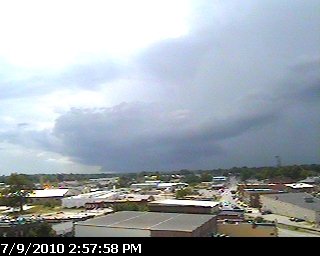
Thunder is rumbling at 3 pm. Note the very dark storm clouds just the northwest and west of Cookeville. Expect more storms in area now!
Sent from my Verizon Wireless Blackberry
BEST CHANCE FOR RAIN THIS MONTH:
Expect storms to develop during the day. Some of these storms could become strong to possibly severe today and early tonight as a cold front moves into our area. It is quite possible for us to see some locally heavy rain and minor flooding. Spotters are encouraged to report anything that reaches reporting criteria.
24-HOUR FORECAST:
We're expecting to only hit 85° this afternoon before rains move in. Low tonight in the upper 60's and lower humidity levels and a north wind will make our high of 87° on Saturday feel much more comfortable.
*Latest Local Forecast*
*Hazardous Weather Outlook*
*Latest Live Radar*
Cookeville's Daily Almanac
Yesterday's high: 96°
Yesterday's low: 67°
Normal High: 87°
Record: 101° in 1988
Normal Low: 65°
Record: 53° in 1918
Last Year: 86° and 62°
2.03" of rain fell on this date in 1916
--------------------------------------------------
Join me on: Facebook Twitter LinkedIn Examiner.com Nashville Weather CookevilleTimes Weather My Google Profile
Nearly 1 inch (.96") has fallen today across much of Cookeville. Checking some other stations, I find .79" at the Emergency Mgmt. Office on Willow Avenue, .66" at Kittrell Hall (Rock Lodge) at Tennessee Tech, .94" out near Cane Creek, .71" in Twin Oak near Baxter, and just .32" up in Cumberland Cove near Monterey.
AT 3 PM:
Thunder is rumbling at 3 pm. Note the very dark storm clouds just the northwest and west of Cookeville. Expect more storms in area now!
Sent from my Verizon Wireless Blackberry
BEST CHANCE FOR RAIN THIS MONTH:
Expect storms to develop during the day. Some of these storms could become strong to possibly severe today and early tonight as a cold front moves into our area. It is quite possible for us to see some locally heavy rain and minor flooding. Spotters are encouraged to report anything that reaches reporting criteria.
24-HOUR FORECAST:
We're expecting to only hit 85° this afternoon before rains move in. Low tonight in the upper 60's and lower humidity levels and a north wind will make our high of 87° on Saturday feel much more comfortable.
*Latest Local Forecast*
*Hazardous Weather Outlook*
*Latest Live Radar*
| Click on graphic to see larger version |
Cookeville's Daily Almanac
Yesterday's high: 96°
Yesterday's low: 67°
Normal High: 87°
Record: 101° in 1988
Normal Low: 65°
Record: 53° in 1918
Last Year: 86° and 62°
2.03" of rain fell on this date in 1916
--------------------------------------------------
Join me on: Facebook Twitter LinkedIn Examiner.com Nashville Weather CookevilleTimes Weather My Google Profile
Thursday, July 8, 2010
Hot Today; Rain Coming Friday
ANOTHER HOT DAY AHEAD:
Expect highs to hit the lower to middle 90's once again today. We saw 94° on Wednesday. The great news is we'll see some changes by tomorrow (Friday) as a frontal boundary pushes closer to our area. Rain will help bring our temperatures down.
At 7 a.m. in Cookeville
| Click on graphic to see a larger view! |
Cookeville's Daily Almanac
This Morning's Low: 66.7°
Yesterday's high: 94.1°
Yesterday's low: 65.1°
Normal High: 87°
Record: 98° in 1930
Normal Low: 65°
Record: 54° in 1984
Last Year: 84° and 61°
4.30" of rain fell on this date in 1979
--------------------------------------------------
Join me on:
Friday, July 2, 2010
Gorgeous Weekend Ahead
Very Nice Holiday Weekend:
July 4th is rapidly approaching and our weather will be quite nice considering we're right in the middle of summer. We started out this morning with a low of 57°. Expect a high this afternoon in the middle 80's and warming each day with 87° on Saturday, and 91° by Sunday. It'll be sunny during the day and clear at night with lows in the lower to middle 60's each evening.
At 8 a.m. in Cookeville, TN
Cookeville's Daily Almanac (7/2/10)
This morning's low: 56.5°
Yesterday's high: 82.2°
Yesterday's low: 62.1°
Normal High: 87°
Record: 97° in 1926
Normal Low: 64°
Record: 46° in 1988
Last Year: 80° and 61°
" of rain fell on this date in
--------------------------------------------------
Join me on:
Thursday, July 1, 2010
Not A Bad Start For July
10:20 PM UPDATE:
Already down to 65° in Cookeville.
I expect mid to upper 50's by sunrise Friday!
Don't get too used to it as upper 80's to near 90 return soon. No rain until about Tuesday.
COMFORTABLE WEATHER ALERT:
Expect daytime highs to reach just 83° this afternoon after morning lows of 62°. I call this a fantastic start to July. We'll gradually warm each day as we go through the Independence Day holiday. By July 4th, we should see highs around 88°.Already down to 65° in Cookeville.
I expect mid to upper 50's by sunrise Friday!
Don't get too used to it as upper 80's to near 90 return soon. No rain until about Tuesday.
COMFORTABLE WEATHER ALERT:
FROM MIDNIGHT TO 7:45 THIS MORNING
| For a larger image, please click on graphic |
--------------------------------------------------
Join me on:
Tuesday, June 29, 2010
Much Nicer Weather Ahead!
MUCH MORE COMFORTABLE WEATHER:
After the showers and thunderstorms on Monday dropped nearly 2/3rds of an inch, we've settled into a much nicer pattern of weather. This morning's temperature is 71.6° at 6:51 am while it was 78.0° just 24 hours ago. Expect a nice Tuesday with highs reaching 87° today. While 87° sounds hot, you'll notice a marked difference in how it feels as the air is continuing to dry out. Tonight, we'll drop to the mid 60's and even lower overnight on Wednesday and Thursday where some of us could dip into the 50's.THIS MORNING AT 7 AM
| To see a larger version, click on the graphic! |
Cookeville's Daily Almanac
Yesterday's high: 92.8°
Yesterday's low: 71.0°
Normal High: 86°
Record: 102° in 1936
Normal Low: 64°
Record: 53° in 1992
Last Year: 89° and 58°
5.21" of rain fell on this date in 1936
--------------------------------------------------
Join me on:
Sunday, June 27, 2010
Super Sunday Forecast
ANOTHER HOT ONE:
Expect temperatures, once again, to climb near 90°. A slight chance of an afternoon thundershower or two. Repeat this forecast for both Monday and Tuesday. Then, I expect a little cool-down midweek through the weekend where temps should be about 5-7° cooler than we've seen during most of this month.
AT JUST BEFORE 8 AM:
SPEAKING OF HEAT:
A little fact about June is that we've seen highs of at least 89° every single day since the 11th. Exactly 12 of those days have been 90°+. We are running 4.4° above normal this month.
Expect temperatures, once again, to climb near 90°. A slight chance of an afternoon thundershower or two. Repeat this forecast for both Monday and Tuesday. Then, I expect a little cool-down midweek through the weekend where temps should be about 5-7° cooler than we've seen during most of this month.
AT JUST BEFORE 8 AM:
SPEAKING OF HEAT:
A little fact about June is that we've seen highs of at least 89° every single day since the 11th. Exactly 12 of those days have been 90°+. We are running 4.4° above normal this month.
Cookeville's Daily Almanac
Yesterday's high: 92.4°
Yesterday's low: 69.9°
Normal High: 86°
Record: 100° in 1944
Normal Low: 63°
Record: 48° in 1958
Last Year: 90° and 68°
1.23" of rain fell on this date in 1923
--------------------------------------------------
Join me on:
Subscribe to:
Posts (Atom)
AMS
Member-American Meteorological Society