Showing posts with label cookeville almanac. Show all posts

Tuesday, July 22, 2014

Back In The 90's

We're finally back in the 90's after more than a week where temps dropped into the upper 60's for actual high temperatures! It felt hot today.

JULY 22 ALMANAC:
Records: 
Hottest: 100° in 1926 (normal: 87°)
Coolest: 53° in 2007 (normal: 66°)
Rainfall:
1.80" this date in 2011
Wettest July: 9.37" (1916)
Month to Date:
Average high: 84.7° 
(normal: 87.3)(record: 95.6° in 1980)


We saw no rainfall today (Tuesday) across the Cookeville area (most showers/storms confined to northeast plateau and southeast TN near Chattanooga and on into NE Alabama and NW Georgia) but have a 40% for Wednesday and a 70% chance of thunderstorms for Wednesday night. I think we will top 90° again on Wednesday. Thunderstorms continue on Thursday early but then we expect to slowly clear with highs in the mid 80's and lows in the low 60's on Thursday night.

For Friday expect a sunny and very nice day with a high of 85° and a low of 62°. Much of the same for Saturday with sunny skies and a high of 85°. The full forecast is below.

*Latest Local Forecast*


Interact with me on social media:
Weather Guy on Facebook
Weather Guy on Twitter
Cookeville Weather Alerts on Twitter


Sunday, January 19, 2014

SUNDAY UPDATE: Cold Air Coming Back Next Week

Has January been cold enough for you? 

I counted up the number of +50° days and believe it or not, we have had 7 of them thus far in January.

That being said, our average high temperature is just 43° and our average low is 19°.

Normals are 46° and 26° for January. It has been COLD.

Speaking of cold, it returns with a vengeance once again beginning Tuesday. Looks like highs in the upper 20's and lower 30's with lows in the teens. There is a slight chance we may even drop into the single digits on Wednesday morning.

I know everyone wants a 'big' snow. Nothing so far YET!

Stay tuned!

*Latest Local Forecast*


Interact with me on social media:


Saturday, June 29, 2013

FLASHBACK: One Year Ago Today - Cookeville Hits 106°

Going into June 29 of last year, we knew it was going to be a very hot day. A dry air mass with stifling daytime heat had set-up over the area. The interesting thing is that the morning low was around 65° at 5 am. Just 12 hours later, the mercury would climb more than 40° topping out at 106° measured by my Northeast Cookeville weather station. The official high was 105° tying the all-time record set back in 1930.

*LIST OF RECORDS SET IN MIDDLE TN*

*June 29 By The Numbers - Heatwave Records*

The map of highs from June 29


One year later, we expect highs only in the lower 80's today with upper 70's on Sunday. Quite a chance from 1 year ago today, don't you think?

*Latest Local Forecast*


Interact with me on social media:


Wednesday, December 12, 2012

Very Cold Wednesday Start

Patchy dense freezing fog has developed near some bodies of water. This has caused some slippery conditions especially on bridges and overpasses. Be careful through the mid-morning hours.

TODAY'S FORECAST:
Temperatures are quite cold this morning as you leave your home with thick frost covering vehicles that are outdoors. The low this morning was 22.8°. Wednesday will be much warmer (47°) compared with yesterday when we had a high of just 38.2°. Skies will be sunny and winds will be fairly light. The bright sunshine will make the day feel warmer.

TONIGHT:
Clear tonight once again and quite cold with a low of 25° by Thursday morning. Thursday's high is expected to be 55°. By Friday, we'll moderate to a high of 58°.

WEEKEND FORECAST:
Your weekend forecast is calling for rain showers on both Saturday and Sunday with mild temperatures. Highs around 60 with lows in the upper 40's.


12/12/12:
Normal High: 50
Normal Low: 29
Record High 77 in 2007
Record Low -9 in 1962
1.78" of rain in 1959
4.4" of snow in 1935


*Latest Local Forecast*


Interact with me on social media:
Weather Guy on Facebook
Weather Guy on Twitter
Cookeville Weather Alerts on Twitter


Sunday, December 9, 2012

Thunderstorms Today and Monday

Big changes lie ahead for the Cookeville area for much of next week but we'll get to that further down in the post.

WET/WARM SUNDAY & SUNDAY NIGHT:
For today (Sunday), we'll have a 50% chance of thunderstorms with a very warm day ahead. The high will reach near 70° (the record high is 70° from 2007). Tonight, our rain chances increase significantly with a 90% chance of showers.


THE BIG DROP STARTS:
On Monday, thunderstorms are in the forecast with falling temperatures. We'll start out around 56° but will fall all day. By 5 o'clock in the afternoon temperatures will be around 42°. Overnight Monday expect the falling temperatures to continue with a low of 30°.


THE WEEK AHEAD:
The huge swing in temperature will continue on Tuesday but we'll see sunny skies. The high will be just 44°. The rest of the week ahead calls for slightly moderating temps with highs on Wednesday in the upper 40's and Thursday in the lower 50's with lows in the 20's.

*Latest Local Forecast*

WHAT A WARM DECEMBER:
December has roared off to a warm start with the average daily high temperature of 66.1° through yesterday (Saturday). In comparison, 1998 is the warmest December on record in Cookeville with an average high of 67.8°. Compared to normal, we are 14° above the average daily high temperature. 


Interact with me on social media:
Weather Guy on Facebook
Weather Guy on Twitter
Cookeville Weather Alerts on Twitter


Sunday, December 2, 2012

Warm Weather Continues

Hard to believe it is early December with temperatures in the mid and upper 60's. We hit 68° earlier today (Sunday) around 1 pm. Temperatures will continue to be very warm throughout the rest of today and near 70° on Monday. Just for perspective, our average high temperature this time of year is 52°. No one is complaining!

Rain showers enter the picture on Tuesday. We will be warm again.

Temps will be 10-15° cooler for Wednesday and Thursday.

Cookeville's November Almanac:
The month of November saw an average high of 58.6° (2° BELOW normal) while the average low was 29.7° (5.8° BELOW normal). This equated to an average temperature of 44.2° (3.9° BELOW normal). Rain was light with just 2.29" (Normal is 4.71").

November Records:
Average high: 68.7° in 2001
Average low 28.0° in 1976 (we were just 1.1° off that record)
Rainfall: 10.20" in 1973
Snowfall: 17.3" in 1966 (this is not a misprint)

*Latest Local Forecast*


Interact with me on social media:
Weather Guy on Facebook
Weather Guy on Twitter
Cookeville Weather Alerts on Twitter


Saturday, October 6, 2012

What A Difference

Did you know the last two days at 9:30 am our temperatures were 69.4° (yesterday) and 67.3° (Thursday)? Today (Saturday) at 9:30 we are nearly 25° cooler at just 45.6° and the wind chill (feels like) has been as low as 43°.

SATURDAY FORECAST:
Cloudy, dreary, and chilly. The forecasted high is 59° but we'll struggle to warm-up all day, so I don't think we'll get close to that number. Scattered showers and cool tonight with a low of 42°. Normal high/low this date is 73/50.

SUNDAY FORECAST:
30% chance of showers early becoming cloudy and more dry in the afternoon with a high of 56°. A slight chance of frost overnight into Monday (if skies clear) with a low of 38°.

*Special Weather Statement*

OCTOBER RAINS:
We are already up to 2.30" of rain this month. To give you a bit of perspective, over the last 30 years October has averaged 3.23" of rainfall. This after 11.50" of rain in September, which is more than 2 and 1/2 times the normal amount of September rain.

2012 ANNUAL RAINFALL UPDATE:
For the year, we've overtaken the normal amount. Currently, we stand at 46.02" while the average is 42.92". This is a huge turnaround considering we were in the 9" plus deficit ranges back in July and considered to be in a drought.

*Latest Local Forecast*


Interact with me on social media:
Weather Guy on Facebook
Weather Guy on Twitter
Cookeville Weather Alerts on Twitter


Monday, September 10, 2012

Mostly Sunny Monday


Another fantastic day on tap for the Cookeville, TN area for Monday with highs around 80° this afternoon after a morning start of 51° for the second straight morning. Expect nothing but sunny skies!

The sunny skies will continue all week with a slight warming trend into the middle 80's with lows at night in the mid to upper 50's. A great taste of late summer/early autumn. It makes us ready for the leaves to change.

Got to love this weather!

*Latest Local Forecast*

Cookeville's Daily Almanac
September 10, 2012
Yesterday's high: 76.8° 
This morning's low: 51.6°
Normal: 83/58
Records: 99° in 1896 and 40° in 1976
Last year: 80/53

Rainfall 
0.00" at my station
September total: 4.37"
2012 total: 36.31"
1.20" of rain fell on this date in 1960


Interact with me on social media:
Weather Guy on Facebook
Weather Guy on Twitter
Cookeville Weather Alerts on Twitter


Monday, August 27, 2012

Sunshine and Hot For Monday

Expect mostly sunny skies with calm winds today and a high of 90°. It'll mark the 4th day in a row that we've topped 88°. Normal high this date is 86°. Tonight, skies become mostly cloudy with a low of 66°. An approaching front will bring a better chance for showers and thunderstorms with a high of 88° on Tuesday.

*Latest Local Forecast*


Isaac's path continues to confound the experts. The storm is now expected to move onto shore in Louisiana and move just west of New Orleans. As most of you know, it is the right side of the hurricanes that typically see the most damage. The system of levees will be tested in a major way for the first time since Katrina.

As far as Isaac affecting Tennessee, we believe the center of the storm will move into Arkansas. Since Isaac is such a large storm, it is possible to see heavy rainfall especially over west Tennessee.

Cookeville's Daily Almanac
August 27, 2012
Yesterday's high: 90.8° *first time at 90° in 16 days*
This morning's low: 63.2°
Normal: 86/62
Records: 100° in 1936 and 49° in 1922
Last year: 88/59

Rainfall 
0.00" at my station
August total: 5.64"
2012 total: 31.94"
2.84" of rain fell on this date in 1992

August continues to be a below average month in terms of temperatures but an above average month in terms of precipitation. Current temps are 2.3° below average and rainfall is about 10% ahead of an average August.

Interact with me on social media:
Weather Guy on Facebook
Weather Guy on Twitter
Cookeville Weather Alerts on Twitter


Saturday, August 25, 2012

Nice Saturday


A great looking day across the Cookeville area for your Saturday with daytime highs reaching the upper 80's to near 90°. There is a very slight (10%) chance for an afternoon thunderstorm. Winds will be from the south southwest at around 5 mph but will become calm late today.

Overnight, expect a partly cloudy sky with a low of 65°. For Sunday, sunshine and a high of 89°. Thunderstorm chances ramp up for Monday and Tuesday. We think the area may be affected by Isaac at some point during the mid-week. That, however, is up in the air at this point. Weather Underground and Weather.com both have full coverage on Isaac.

*Wunderground Isaac Page*

*Latest Local Forecast*

Cookeville's Daily Almanac
August 25, 2012
Yesterday's high: 89.9° *first time at 90° in 16 days*
This morning's low: 65.6°
Normal: 87/63
Records: 100° in 1943 and 49° in 1917
Last year: 94/65

Rainfall 
0.00" at my station
August total: 5.64"
2012 total: 31.94"
1.77" of rain fell on this date in 1958


Interact with me on social media:
Weather Guy on Facebook
Weather Guy on Twitter
Cookeville Weather Alerts on Twitter


Thursday, August 23, 2012

Another Sunny Day After A Cool Start

If you're a fan of cool nights and warm sunny days then this is the weather for you. We start out the morning at 55.7° the fifth day in a row in the 50's. This afternoon temps will climb into the upper 80's with a calm wind and sunny, clear skies. Overnight, expect another cool night with lows near 60, I believe we'll drop down to the 50's for the sixth straight night. On Friday, we'll push 90°.

SUNNY SKIES THROUGH WEEKEND:
The pretty weather continues through the weekend with rain expected by Monday and Tuesday of next week.

AIR QUALITY ALERT:
A 'Code Orange' Air Quality Alert is in effect on Thursday (today) for counties surrounding the Nashville area. The closest one to Putnam County is Smith County to our west.


LATEST TRACK ON TROPICAL STORM ISAAC:
Residents of Florida BE ON THE LOOKOUT for Tropical Storm Isaac. The current track takes over the Dominican/Haiti this weekend and then onto Cuba Sunday and then into the Gulf near Key West on Monday and up the west coast of Florida Tuesday. It is still early and this track may change.

*Latest Local Forecast*

Cookeville's Daily Almanac
August 23, 2012
Yesterday's high: 84.3° 
This morning's low: 55.6°
Normal: 87/63
Records: 104° in 2007 and 50° in 1997
Last year: 91/58

Rainfall 
0.00" at my station
August total: 5.64"
2012 total: 31.94"
1.77" of rain fell on this date in 1958


Interact with me on social media:
Weather Guy on Facebook
Weather Guy on Twitter
Cookeville Weather Alerts on Twitter


Wednesday, August 22, 2012

Sunshine and Warm Through Sunday

We wake up once again to temperatures in the 50's across middle Tennessee. Here in Cookeville, the 7 am temp is 55.9° and the low this morning was 54.4°, the 4th straight morning with lows in the 50's.

SUNSHINE THIS AFTERNOON:
We'll hit 85° later this afternoon under a sunny sky. Ditto that forecast for tomorrow through the weekend as we stay in the dry pattern with warm days and cool evenings.


Tropical Storm Isaac is churning in the Atlantic and expected to reach hurricane status in the next 24-36 hours. The path is expected to take Isaac toward Cuba and then make a turn toward Florida. At this point, we expect the Atlantic coast of south Florida to be under the gun by around 2 am on Monday. This, however, is a long ways out and the path could easily change.

*Latest Local Forecast*

Cookeville's Daily Almanac
August 22, 2012
Yesterday's high: 82.4° 
This morning's low: 54.4°
Normal: 87/63
Records: 100° in 2007 and 47° in 1956
Last year: 87/58

Rainfall 
0.00" at my station
August total: 5.64"
2012 total: 31.94"
1.20" of rain fell on this date in 1966

Month-to-date highs for August are averaging 84.3°, which is 3° below normal and some 11° below the record heat from 2007. Low temps are running about 1° below normal but 6° above the coolest year ever, which was in 2004. Rainfall is nearly double the normal and most of us are thrilled with the extra rainfall. Did you know that nearly 11" had fallen thus far in August of 2010?


Interact with me on social media:
Weather Guy on Facebook
Weather Guy on Twitter
Cookeville Weather Alerts on Twitter


Thursday, August 16, 2012

Nice Start With A Warm Day Ahead

We began the morning at 59° and expect temperatures to warm up quickly after the sun rises. We'll top out at 87° this afternoon under a sunny sky. Winds are expected to be mainly calm.

Tonight, increasing clouds and a low around 69° and we'll see a slight chance of showers and thunderstorms. For Friday, showers and thunderstorms are likely with a high in the lower 80's. Rain chances continue Friday night, but the weekend is expected to be quite nice with highs in the 70's and lows in the 50's under sunny skies.

Much of next week will be cool and clear with warm, sunny days and very comfortable evenings.


Football Forecast:
The Cookeville High School 9th grade team takes on Pope John Paul II (JP2) tonight. JP 2 is coached by former longtime and very successful Cookeville coach Jerry Joslin. Kickoff is slated for 6 pm and I expect a temperature of 84° and light SSW wind at 2 mph. There is a very slight rain chance.

*Latest Local Forecast*

Cookeville's Daily Almanac
August 16, 2012
Yesterday's high: 84.4° 
This morning's low: 59.0°
Normal: 87/64
Records: 102° in 2007 and 50° in 1979
Last year: 84/57

Rainfall 
0.00" at my station
August total: 5.05"
2012 total: 31.35"
2.76" of rain fell on this date in 1944


Interact with me on social media:
Weather Guy on Facebook
Weather Guy on Twitter
Cookeville Weather Alerts on Twitter


Wednesday, August 15, 2012

Morning Fog Gives Way To Sunshine


Becoming mostly sunny today (after morning fog lifts - see webcam shot below) across the area with highs in the mid 80's. A northwest wind around 5 mph this afternoon. Overnight, a cool and comfortable evening with lows right around 60° and again areas away from the city of Cookeville will be cooler.


On Thursday, it'll be a mostly sunny day with highs in the upper 80's as the wind turns more southerly. We'll see shower chances develop on Thursday night along with cloudy skies. A low in the upper 60's. Showers and thunderstorms are likely on Friday with a high in the lower 80's. Chance of rain is 60%. The rain and thunderstorm chances hang on Friday night.

The weekend forecast is for a slight shower chance on Saturday morning and then becoming a mostly sunny day with highs near 80°. Mostly sunny on Sunday with highs in the low 80's. Lows this weekend will be in the upper 50's.

*Latest Local Forecast*


The above graphic shows the shortfall or deficit in rainfall for 2012. As you can see, we're still down by a significant amount. Thankfully, however, we have had some good rainfall (almost 9") in the last 30 days to cut into the shortage. 

Cookeville's Daily Almanac
August 15, 2012
Yesterday's high: 82.3° 
This morning's low: 65.1°
Normal: 87/64
Records: 102° in 2007 and 50° in 2004
Last year: 78/56

Rainfall 
0.00" at my station on Monday
August total: 5.05"
2012 total: 31.35"
3.57" of rain fell on this date in 1964

So far, high temps for August have been running a couple of degrees BELOW normal. Precipitation is significantly ahead of normal. All in all, August is a cooler, wetter month. Something we've not seen in quite a while. 


Interact with me on social media:
Weather Guy on Facebook
Weather Guy on Twitter
Cookeville Weather Alerts on Twitter


Tuesday, August 14, 2012

Slight Storm Chances This Morning; Nice Day Ahead


Look for a very nice day with highs in the lower 80's this afternoon as skies become partly sunny. We'll be cool once again overnight with lows in the lower 60's. Sunshine for Wednesday and Thursday with highs of 85° and 88° respectively. Storm chances return later this week and a cooler weekend on tap with sunny skies.

*Latest Local Forecast*

A NICE AND COOL RUN:
Between Saturday morning, Sunday morning, and Monday morning, we had lows in the 50's. This was the first time that had happened since June 5-9 earlier in the late spring.

Cookeville's Daily Almanac
August 14, 2012
Yesterday's high: 81.2° 
This morning's low: 66.9°
Normal: 87/64
Records: 98° in 2007 and 49° in 2004
Last year: 84/60

Rainfall 
0.05" at my station on Monday
August total: 5.05"
2012 total: 31.35"
1.62" of rain fell on this date in 1920


Interact with me on social media:
Weather Guy on Facebook
Weather Guy on Twitter
Cookeville Weather Alerts on Twitter


Sunday, August 12, 2012

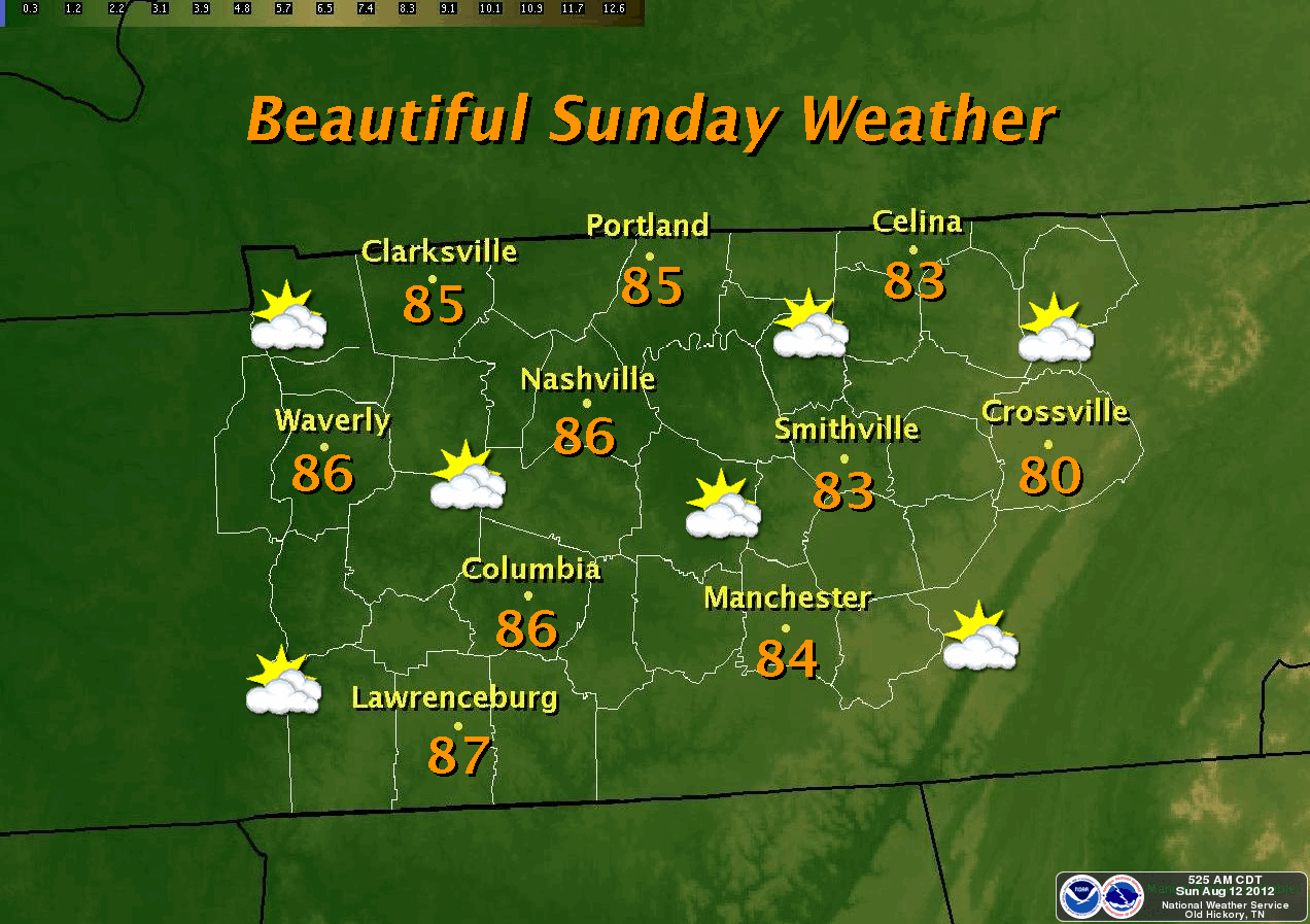
Gorgeous Sunday


NOTHING LIKE THE 50's
A very cool start across the Cookeville area this morning as temps were in the 50's for the second morning in a row. We dropped to a low of 52.7° (the record low was 49° in 1964), which is the coolest morning reading since the sixth of June when we had a low of 50.6°.

**Don't forget to like our FACEBOOK page**


COMFORTABLE SUNDAY
Expect Sunday highs under sunny skies (see this morning's web cam shot above) to be around 83°, which is about 5° higher than yesterday's 78.5° maximum. It was just the third day this summer we hadn't been in the 80's, 90's, or 100's.

STORMS EARLY WEEK, BUT COOLER WEATHER COMING
Our work week will begin with a slight chance of storms on Monday with a better chance on Monday night and Tuesday. Expect warmer temperatures on Monday with highs in the mid-upper 80's and muggy-like conditions. After frontal passage on Tuesday, we'll be back down in the comfortable range (much like this weekend) and then temperatures heat up for the end of the upcoming week. By the weekend however, another front brings cooler weather once again.

*Latest Local Forecast*

Cookeville's Daily Almanac
August 12, 2012
Yesterday's high: 78.5° 
This morning's low: 52.7°
Normal: 87/64
Records: 98° in 1925 and 49° in 1967
Last year: 88/62

Rainfall 
0.00" at my station on Thursday
August total: 5.00"
2012 total: 31.30"
1.65" of rain fell on this date in 1937


Interact with me on social media:
Weather Guy on Facebook
Weather Guy on Twitter
Cookeville Weather Alerts on Twitter


Friday, August 10, 2012

Rain This Morning; Great Weekend Ahead


Showers and thunderstorms are likely today, especially this morning, with a high of around 83°. I don't think it will be an all day washout and do see us having at least some partly cloudy skies later in the day.

Yesterday we saw heavy rains fall at lunch with 1.69" measured at my station. This gives us 4.89" for the month of August and that is 1.06" MORE than the entire month's average for August. Through 9 days, the typical average for August is 1.08".

The great news is we'll transition out of the rainy pattern and have a very nice weekend with plenty of sunshine and the high on Saturday struggling to reach the 80's and into the mid 80's for Sunday.

We've seen some showers this morning across the Cookeville area.

*Latest Local Forecast*

Cookeville's Daily Almanac
August 10, 2012
Yesterday's high: 81.8° 
This morning's low: 67.9°
Normal: 87/65
Records: 98° in 1980 and 51° in 1967
Last year: 88/65

Rainfall 
1.69" at my station on Thursday
August total: 4.91" (thru yesterday)
2012 total: 31.19"
2.44" of rain fell on this date in 2006


Interact with me on social media:
Weather Guy on Facebook
Weather Guy on Twitter
Cookeville Weather Alerts on Twitter

Wednesday, August 8, 2012

Hot, Highs In The 90's

We return to stifling heat today across much of the area.

There is an Air Quality Alert for the surrounding counties near Nashville.

Look for highs to reach in the lower 90's here in Cookeville and middle 90's in much of the rest of middle TN. The heat will stay in place for Thursday but thunderstorm chances increase significantly with likely thunderstorms on Thursday night and again on Friday.

The weekend actually looks quite nice with chilly overnight temperatures around 60° and highs only in the lower 80's!

*Latest Local Forecast*

Cookeville's Daily Almanac
August 8, 2012
Yesterday's high: 88.4° 
This morning's low: 68.3°
Normal: 87/65
Records: 104° in 1930 and 48° in 1989
Last year: 92/69

Rainfall 
0.00" at my station (on Sunday)
August total: 3.20" (thru Sunday)
2012 total: 29.50"
1.76" of rain fell on this date in 1996

The average August high temperatures through the first week of the month are normal while precipitation is more than double the amount of normal. Back in 1942, there was 6.39" of rain recorded in the first week of the month.


Interact with me on social media:
Weather Guy on Facebook
Weather Guy on Twitter
Cookeville Weather Alerts on Twitter


Monday, August 6, 2012

More Rain Forecast For This Week

With more than 3" of rainfall recorded thus far in August, we're quickly making up ground lost to the drought over much of the area.

We usually don't celebrate a rain-filled weekend but with the lack of rain over the area, I don't think there were too many people complaining.

The rainfall amounts recorded over the last several days are as follows:
Friday: .80"
Saturday: 1.16"
Sunday: .82"
Monday (thus far): .41"

This gives us 3.19" for August. Typically, August averages just 3.83" for the entire month.


MONDAY FORECAST:
Expect a good chance for rain today with most coming in the morning. Thunderstorms may possibly develop later this afternoon. Chance of thunderstorms is 60% with an afternoon high of 85°. Temperatures will warm up for the rest of the week with highs topping 90° Tuesday-Thursday and a rain chance each day.


*Latest Local Forecast*

Cookeville's Daily Almanac
August 6, 2012
Yesterday's high: 82.4° 
This morning's low: 69.9°
Normal: 87/65
Records: 96° in 1991 and 50° in 2004
Last year: 79/71

Rainfall 
0.82" at my station (on Sunday)
August total: 2.78" (thru Sunday)
2012 total: 29.09"
1.97" of rain fell on this date in 2010


Interact with me on social media:
Weather Guy on Facebook
Weather Guy on Twitter
Cookeville Weather Alerts on Twitter


AMS

AMS
Member-American Meteorological Society