Showing posts with label cocorahs. Show all posts

Sunday, May 5, 2013

Rainfall By Month - Wet 2013


2013 is off to a fast start with precipitation
The top number is the actual amount measured and the bottom number is the average amount for that particular month. Contact me with any questions.

January:
6.35"
Average: 5.07

February: 
2.35"
Average: 4.89

March: 
6.44"
Average: 4.82

April: 
7.09"
Average: 4.53

May: 
3.14"
Average through 5 days: .89

The total thus far in 2013 is: 25.37"
Average from Jan 1-May 5 is 20.02"
2013 precipitation is 26.7% ahead of average.

*Source: My Weather Station (Davis Vantage Vue)*

Are you interested in measuring rainfall for a great cause? 
Learn more at CoCoRaHS or contact me.


*Latest Local Forecast*


Monday, October 15, 2012

Sunny, Windy, and Cool


Expect skies to clear this morning with sunny skies expected for your Monday. There will be a strong northwesterly wind gusting to 25 mph at times today. The high is expected around 67° after our start in the mid 50's this morning. It'll feel a bit chillier due to the winds. Mostly clear tonight with a low around 41° by morning. Tuesday's high will be around 70° with light southwest winds.

Next rain chances are expected Wednesday night with a high on Wednesday of 75°. Rain is expected to last through Thursday night. The upcoming weekend looks mild and sunny.

Speaking of rain, we recorded .47" during the last 24 hours. This puts our October total at 3.24", which is nearly average for an entire month and we're just at the halfway point!

*Latest Local Forecast*


Interact with me on social media:
Weather Guy on Facebook
Weather Guy on Twitter
Cookeville Weather Alerts on Twitter


Sunday, October 7, 2012

Cool Weather Ahead


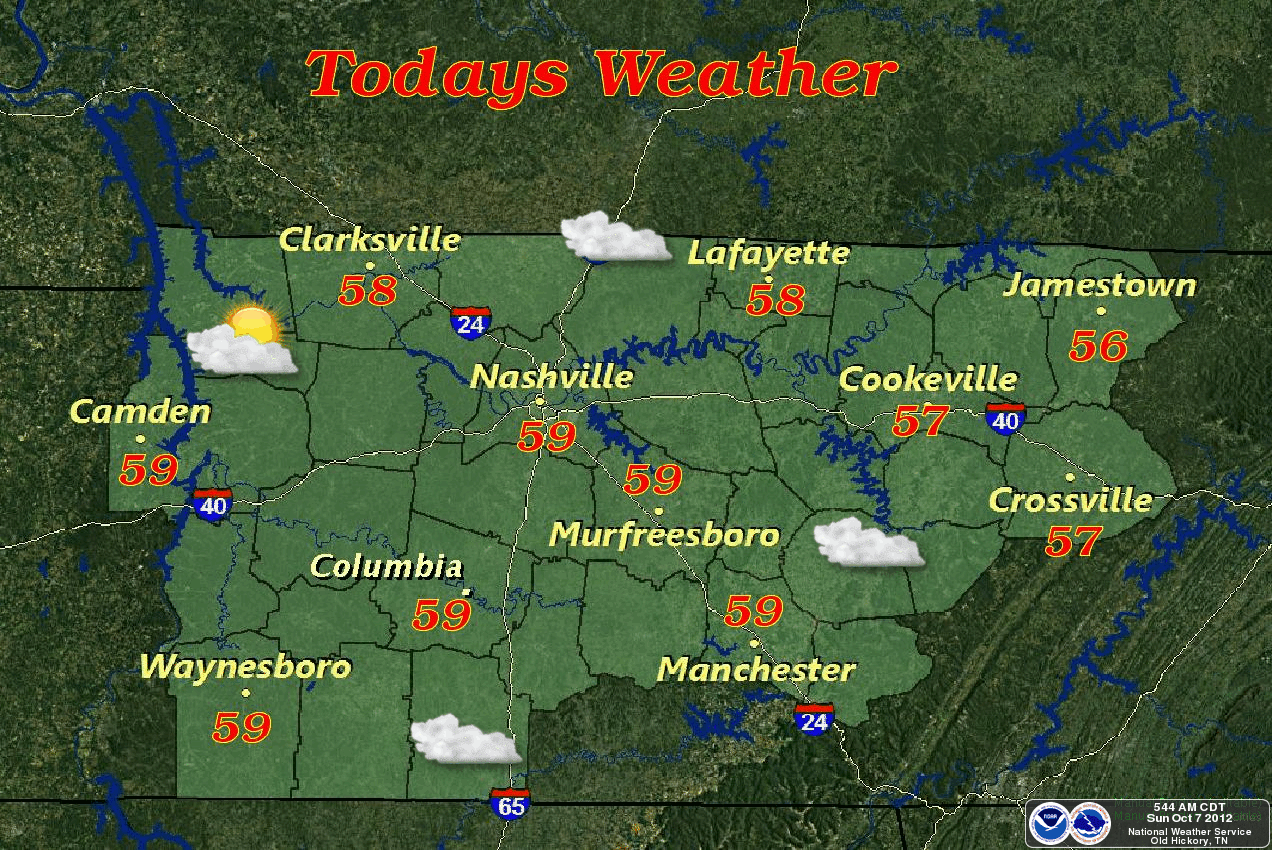
It is a chilly 46° this morning at 8:30 am. Expect this afternoon's highs to only be in the upper 50's. Hard to believe average high this time of year is 74°. Skies do have a chance to become partly cloudy today so upper 50's may feel so chilly. All of middle TN will be in the 50's today.

RAINFALL AND COCORAHS:
We measured .10" of precipitation in the rain gauge during the last 24 hours ending this morning at 8 am. This gives us a total of 2.40" for the month of October. By the way, the rainfall is measured using a 4" diameter gauge and reported to CoCoRaHS.org. If you want to volunteer for this program, please go to their website or contact me via e-mail.

COLUMBUS DAY WEATHER:
Tonight, clouds and rain chances return with a low in the 40's. The frost will hold off here in Cookeville but is more likely west of Nashville as skies will clear once again. Slight rain chances for Columbus Day in Cookeville with a high of just 62°. The sun will shine later in the day. Chilly Monday night with a low around 40°. I think we'll escape the frost again.

EXTENDED FORECAST:
Sunny and 68° for the high on Tuesday, slight rain chance and 67° on Wednesday, and sunshine with a high of 68° on Thursday.

*Latest Local Forecast*


Interact with me on social media:
Weather Guy on Facebook
Weather Guy on Twitter
Cookeville Weather Alerts on Twitter


Monday, October 1, 2012

Wet Monday Forecast

Rainfall will continue across all of middle TN today with some thunder expected. Rain chances today are 90%. There is a chance for isolated severe storms today in southeast middle TN generally from a line from Woodbury to Shelbyville and points eastward. So, if you're going to Chattanooga from Cookeville today, keep an eye to the sky. Expect a high of 72° here in Cookeville, TN.

Overnight, we recorded .70" of rain. A great way to start the month of October!

We finished September with 11.50".

For the next several days, expect a 70% chance of rain tonight and a low of 60°. For Tuesday, a 30% chance of showers and a high of 71°. A slight chance of rain on Wednesday with peeks of sunshine and a high of 75°. We'll finally clear out for Wednesday night and Thursday where we will see of a high of 78°.

*Hazardous Weather Outlook*

*Latest Local Forecast*


Interact with me on social media:
Weather Guy on Facebook
Weather Guy on Twitter
Cookeville Weather Alerts on Twitter


Saturday, September 29, 2012

Cloudy Start, Sunny Afternoon

A chilly and cloudy start this morning with temperatures in the middle 60's. We'll have a light north wind becoming north northwest from 5 to 10 mph later today. We'll eventually begin to see the clouds breaking up with a partly sunny sky. The afternoon high will be in the mid 70's.

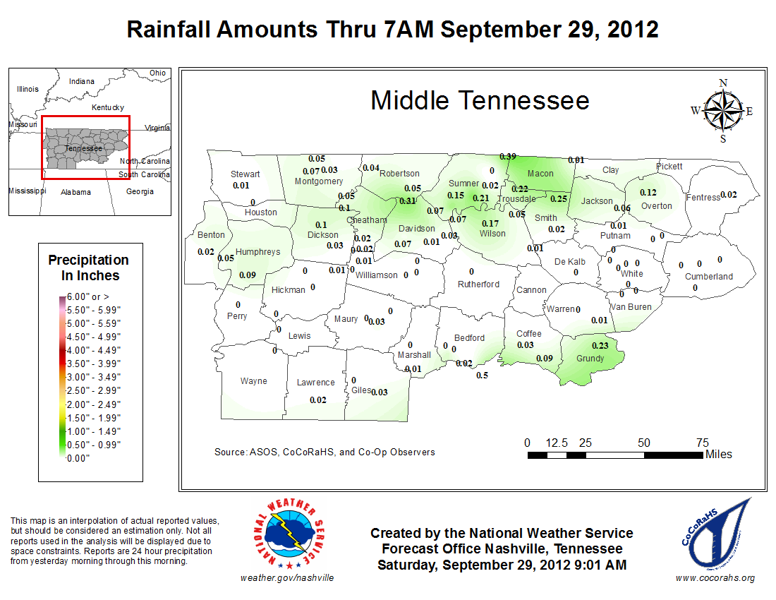
Note the very light and scattered nature of measurable rainfall in the last 24 hours.
Click on graphic to enlarge.


Overnight, patchy fog will develop after 3 am with a low of 54° by Sunday at sunrise. The fog will stay around until around 7 am for most areas. We'll become partly sunny with a high of 72° and winds will be northeast around 5 mph.

Showers likely overnight Sunday into Monday lasting through Tuesday. The best chance for rain is early Monday morning all the way through Monday night. Expect highs on Monday around 70°. Highs next week will mainly be in the 70's with sunny skies by Wednesday. Lows mainly in the 50's.

*Latest Local Forecast*


Interact with me on social media:
Weather Guy on Facebook
Weather Guy on Twitter
Cookeville Weather Alerts on Twitter


Sunday, August 5, 2012

Sunday Thunderstorms, Some Possibly Strong to Severe


Thunderstorms will be likely for your Sunday across much of the middle Tennessee region. Expect highs to climb into the upper 80's this afternoon. Some of these thunderstorms could reach severe limits and the National Weather Service believes there is a slight risk. The primary threats are damaging straight-line winds and large hail. Additionally, brief, localized flooding resulting from heavy rainfall is also possible.

*Latest Local Forecast*

*Saturday's Cocorahs Rainfall Map from Middle Tennessee*
Some impressive rain amounts from Saturday's storms in Middle TN. 3.18" in Wilson County, 2.22" in Trousdale County, 1.77" in Sumner County, and 1.40" in Putnam County.


Interact with me on social media:
Weather Guy on Facebook
Weather Guy on Twitter
Cookeville Weather Alerts on Twitter


Monday, February 20, 2012

Rain-Filled Week Ahead


After a snowy Sunday and a very nice Monday in which we saw much of the snow melt, the week ahead is promising two things......wind and rain. Temperatures should be quite nice but much cooler on Friday.

MONDAY'S NUMBERS:
First off, we saw a low this Monday morning of 22.1° at 6:34 am while the high this afternoon went all the way up to 52.2° at 4:22 pm. Our average high this time of year is 51°. There were numerous reports of slippery roads early this morning due to freezing fog conditions overnight.

WHERE DID THE SNOW FALL:
The big winner in snowfall yesterday was a 4.8" amount reported from near Jamestown in Fentress County. See the CoCoRaHS spotter map above. Much of our area was in the 1-2" range with a Monterey amount of 3". The snow was nice while it lasted. There is no hint of snow in the 7-day forecast below.

RAIN AND WIND THIS WEEK:
Let's look at the next few days. Expect showers to develop overnight and the winds will definitely pick up by daybreak. High Tuesday of 56° with wind gusts to 25 mph with a 20% chance of showers early. Rain chances again on Wednesday, high of 62° with winds gusting once again to 25 mph and about a 20% chance of rain. Thursday shows a 30% chance for showers and thunderstorms with a high of 68° and another windy day. Much cooler Friday, high only 48° along with a 40% chance of showers and continued windy conditions.

The weekend is expected to be sunny with a chilly day Saturday (high 44) and a warmer day Sunday (high 56).


Tuesday, February 7, 2012

Cold Start Includes Frost But Warmer Day Ahead


It's a chilly start across much of the Upper Cumberland this morning with plenty of frost. Some areas, especially around rivers and lakes, are dealing with freezing fog. Temperatures are in the middle 20's at 7 am. Later today, expect the high to reach 53° in Cookeville, TN.


Overnight - Rain showers will be mostly scattered. There is a slight chance the rain may mix with snow and a low of 37°. Rain and snow chances 60%. Little or no snow accumulation and temperatures won't be cold enough for the snow to stick to road surfaces.

Wednesday - Just a 20% chance of rain showers before noon. Hi of 46°.

Rest of week - We're going to be in a cooler period with highs in the upper 40's to near 50° backing down to around 40° on Saturday. Lows will generally be below freezing each night with teens expected on Saturday night. A slight chance of snow flurries for Friday night.


Recruiting for CoCoRaHS - Are you someone who likes to measure rainfall in your backyard? Then CoCoRaHS needs you!


Saturday, February 4, 2012

Rain and Fog Overnight


SATURDAY EVENING UPDATE:
Lingering drizzle and rain tonight with fog developing. Low around 48°. Calm wind.....on Sunday, expect a slight chance of showers and a high of 53°. Showers stay around on Sunday night until just before midnight with a low of 34° under a mostly cloudy sky. The photo above is a camera shot from the tower at the Cookeville-Putnam County Emergency Management Agency on Willow Avenue. Note the fog.

HOW MUCH DID WE GET:
On Saturday, we measured .56" of rain. This gives us 1.50" for February through 4 days and 6.97" for the 2012 year. We are substantially ahead of normal.

ANY SNOW ON THE HORIZON:
The short answer is no as next 7 days don't contain any drastically colder temperatures although late next week we may see highs only in the 40's.


BLOG ADDITIONS:
Under the 'Climate and Rainfall Data' tab at the top of the blog, you'll notice some changes that include the 2012 monthly precipitation summary along with measurements from the CoCoRaHS observers here in Putnam County.


Wednesday, September 7, 2011

Slight Rain Chances and Continued Cool


STAYING LIKE FALL:
This taste of autumn-like weather hangs on (although we're still 2 weeks away from the start) as we'll stay in the lower to middle 60's across the Upper Cumberland region today. There is a 50% chance for showers and it'll mainly be for the morning hours. Rain chances decrease for tonight through the weekend with increasing temperatures each day.

SUPER RAINS:
Totals from what was left of Tropical Storm Lee racked up some impressive totals right here in Putnam County. It seems the northwest section of our city/county had the most with nearly 7" recorded. Up in Monterey, they had almost 6 and 1/4 inches and in the downtown Cookeville area, nearly 6" was recorded at various sources. The highest total in Tennessee belongs to the Cleveland/Chattanooga areas with between 12" all the way up to 13.42" at a station just 3 miles to the ESE of Cleveland, TN in Bradley County.


COOLEST DAY SINCE WHEN?:
Tuesday's high of 59.9° was the coolest high temperature since a high of 58° way back on May 18th, a span of 108 days! Speaking of 59.9° degree high, did you know our typical high for September 6th is 85° and we were 25° above normal. To put that in perspective, if we were 25° ABOVE normal, the high would have been 110°. Tuesday's rain's were a record in Cookeville and I expect this morning's observation will produce another record.


Cookeville's Daily Almanac
Our morning low: 57.8°
Yesterday's high: 59.9°
Yesterday's low: 57.2°
Last Year: 88° and 49°
Normal High: 84°
Normal Low: 60°
Records: 104° in 1925 and 45° in 1988

Rainfall Report
24-hour precip total: 
1.14" (midnight to midnight)
(via my Davis Vantage Vue) 
.55" (7 am yesterday to 7 am today)
(via the CoCoRaHS gauge)
September monthly precip total: 5.90"
2011 annual precip total: 54.19"
0.60" of rain fell on this date in 1923
Wettest Spot in America: 5.67" St. Petersburg, FL (Pinellas County)

Friday, August 19, 2011

Heat Continues Through Next Week

We'll have another hot day today (Friday) along with some scattered thunderstorms with highs around 90° for the third day in a row with our low by Saturday morning of around 70°. Copy that same forecast for Saturday, Sunday, Monday, Tuesday, Wednesday, and Thursday in the 7-day outlook!

Thursday's high was 92° for the second day in a row.

August has been a dry month with just .84" in our CoCoRaHS rain gauge. A typical August sees us receive 4.11". Climate data and rainfall page is located here.


Sunday, July 31, 2011

August Opens Up Hot

HEATING UP AGAIN
The week ahead will be the hottest so far this summer as we end July and start August. Typically, in Cookeville, Tennessee, the warmest week of the year occurs between the second and fourth week of July. A heat advisory is already up for portions of west Tennessee and I expect middle Tennessee will get into the act in the next day or two.

Having some software issues with my weather station since last evening, so the current temperature may not be correct. ..will update when it is working. UPDATE @ 10:14 AM....My Weather Station LIVE is now working properly...

HOT WEEK AHEAD
We'll have a slight chance for storms today (Sunday) with patchy fog overnight and then the heat roars back with a vengeance on Tuesday and Wednesday. Highs may even reach near 100° on Wednesday. Rain chances will be non-existent for most of this week with our best chances coming next weekend.

Speaking of rain, we picked up .65" on Saturday with many areas seeing either very little or picking up quite a bit with the summer storms.

*Latest Local Forecast*

Cookeville's Daily Almanac
Our morning low: 70.5°
Yesterday's high: 86.7°
Yesterday's low: 72.1°
Last Year: 88° and 69°
Normal High: 88°
Normal Low: 65°
Records: 98° in 1999 and 51° in 1965

Rainfall Report
24-hour precip total: 0.65"
July monthly precip total: 3.86" (normal = 5.07")
2011 annual precip total: 47.30"
1.26" of rain fell on this date in 1998
Wettest Spot in Tennessee: 2.68" near Mt. Juliet in Wilson County
Wettest Spot in America: 2.92" near Hazel Green in Madison County, AL

Tuesday, July 26, 2011

Hot and Dry

FORECAST DISCUSSION:
All of the anticipated rainfall missed us on Monday. Areas further to our east and southeast picked up rain though. Expect the rest of the week to be hot with a few scattered afternoon thunderstorms by Friday and Saturday. The next couple of days, will be sunny with highs each day in the 90's!

*Latest Local Forecast*

Cookeville's Daily Almanac
Our morning low: 69.4°
Yesterday's high: 87.9°
Yesterday's low: 74.5°
Last Year: 92.2° and 74.8°
Normal High: 88°
Normal Low: 65°
Records: 96° in 1966 and 55° in 1924

Rainfall Report
24-hour precip total: 0.00"
monthly precip total: 3.20"
annual precip total: 46.64"
4.14" of rain fell on this date in 1973
Monday's Wettest Spot in Tennessee: 1.16" in Baileyton, TN (Greene County)
Wettest Spot in America: 5.80" in Oak Island, NC (Brunswick County)

Sunday, July 24, 2011

Sunny Sunday Forecast

No video forecast today due to lack of time to produce it. Look for one later this afternoon.

FORECAST DISCUSSION:
Hot Sunday for most of us with highs around 91° and the heat index will, once again, push past 100°. Some hit and miss thunderstorms. Most of us will be missed. Best rain chances come Monday as the expected increase in moisture from a frontal boundary is about 24 hours late arriving. Heavy rainfall is expected with this event on Monday. Remember, the best links to weather radars are located on this blog near the top under the heading "RADAR LINKS".

YOUR 48 HOUR QUICK-CAST:
Sunday night - Rain chances increase - low 74°
Monday - Storms likely, heavy rain - high 87°
Tuesday - Sunny - high 91°


Cookeville's Daily Almanac
Our morning low: 73.2°
Yesterday's high: 92.9°
Yesterday's low: 71.8°
Last Year: 94.7° and 70.7°
Normal High: 88°
Normal Low: 66°
Records: 100° in 1934 and 55° in 1915

Rainfall Report
24-hour precip total: trace
monthly precip total: 3.20"
annual precip total: 46.64"
1.62" of rain fell on this date in 1960
Saturday's Wettest Spot in Tennessee: 1.45" in Maynardville (Union County) 
(about 30 minutes due north of Knoxville in East TN) 
Saturday's Wettest Spot in America: 3.92" in Westerville, Ohio (Delaware County) 
(north of Columbus, Ohio)

Saturday, July 23, 2011


FORECAST DISCUSSION:
Another hot weekend for Middle Tennessee. Already seeing heat index readings in the middle 90's this morning and the heat doesn't appear to be letting up anytime soon. I do expect to see an increased chance of storms for Sunday with some possibly damaging storms as well. The week ahead is definitely going to be HOT under mostly sunny skies.

CLIMATE UPDATE:
As hot as it has seemed, we are only .7° (that is just over 1/2 a degree) higher than normal for the first 22 days of July and just over 1/2 a degree lower than July 2010. Typically, we average 87.6° during that period. The all-time record (for the first 22 days in July) is 95.0° set in 1980.

We are slightly behind for the month in rainfall, but one good shower will catch us up for the month while 2011 is far ahead of normal with 46.64" recorded thus far and the typical year sees just over 34" through July.


Cookeville's Daily Almanac
Saturday, July 23, 2011
Our morning low: 71.8°
Yesterday's high: 93.5°
Yesterday's low: 70.2°
Last Year: 95.6° and 71.8°
Normal High: 88°
Normal Low: 66°
Records: 99° in 1983 and 54° in 2007

Rainfall Report
24-hour precip total: 0.00"
July's monthly precip total: 3.20"
2011 annual precip total: 46.64"
1.68" of rain fell on this date in
Yesterday's Wettest Spot in Tennessee: 3.21" in Kingsport, TN (Sullivan County)
Yesterday's Wettest Spot in America: 7.25" in Arlington Heights, IL. (Cook County) - a Chicago suburb

Saturday, July 16, 2011

Saturday Thunderstorms Possible


WEEKEND FORECAST:
Your Cookeville, TN forecast includes a variety of summer-like weather conditions, including thunderstorms, sunshine, and blazing heat once again. We'll see the hottest weather during the mid-week coming up where temperatures will zoom back into the middle 90's. Before that happens, however, we'll deal with some chances for rainfall over the weekend with highs Saturday in the middle 80's and Sunday in the upper 80's. Neither today nor Sunday will be a complete washout, so get out and enjoy your weekend!

FRIDAY'S RAINFALL:
Just .03" was reported here at my station while my friend, Phil Adams, who lives in south Cookeville noted at least 2" at his home. The hit or miss variety of yesterday's rainfall is a typical summer pattern. Phil and I are just about 6 miles apart. Just 4 miles south of Monterey, TN (just out of our county) 2.55" was recorded from yesterday. We have a new feature below showing the wettest spot in Tennessee and in America. Check it out!


Cookeville's Daily Almanac
July 16, 2011
Our morning low: 71.1°
Yesterday's high: 87.9°
Yesterday's low: 72.9°

Last Year: 96.7° and 69.8°
Normal High: 88°
Normal Low: 66°
Records: 101° in 1980 and 51° in 1967

Rainfall Report
July 15, 2011 
24-hour precip total: .03"
June's rainfall total: 2.06"
2.09" of rain fell on this date in 2009
Wettest Tennessee spot: Petros (Morgan County) 3.55"
Wettest spot in America: Skidaway Island, GA 6.04"

------------

Join me on:

on TWITTER


Friday, August 20, 2010

Comfortable Start, Becoming Quite Warm

Awesome Morning:
Have been outside early this morning? Temperatures were in the 60's to start, just after sunrise. We'll rise through the 70's this morning to a high of 90° by late this afternoon. Some areas, especially low-lying and around bodies of water, are dealing with dense fog. Nice weekend coming, but rain is set to return late Saturday night into Sunday.

Rainfall Measurements:
Some incredible numbers are coming out concerning the rain from Tuesday and Wednesday. The map below is clickable and shows amounts across Tennessee and a closer look across the Middle TN section.  Map number 3 is the 24-hour rainfall amount. Some amazing numbers.


Several of you have asked me and I can confirm that we received more rain in a shorter period of time from this system than the devastating floods from last September. I'll have more information to share in the coming days.


Putnam County Rainfall This Week:
CoCoRaHS Stations showed we received as little as 3.25" up in Monterey to 5.66" in southeast Cookeville up to 7-8" northeast of town to 11-12" north of Cookeville. The highest amount was station TN-PM-19 with 12.49". They are located 6.5 miles northwest of the courthouse square. The most severe damage in the county was out that way. CoCoRaHS is so valuable and you can join completely free with a nominal cost for the rain gauge. E-MAIL ME for more information or visit the CoCoRaHS website.


Cookeville's Daily Almanac
Yesterday's high: 86.6°
Yesterday's low: 69.1°
Normal High: 87°
Record: 101° in 1936
Normal Low: 63°
Record: 53° in 1940
Last Year: 84° and 69°
1.76" of rain fell on this date in 1988
10.57" this month at COOP station is new record for August
Daily rainfall records were set on two days this past week.

--------------------------------------------------

Join me on: Facebook Twitter LinkedIn Examiner.com Nashville Weather CookevilleTimes Weather My Google Profile

Thursday, July 22, 2010

Strong Storms Possible Again

HEAT CONTINUES:
Look for the possibility of strong storms to develop again this afternoon. The best chances will be here on the Highland Rim and locations to our north. Highs will be in the 90's for all of us. 92° in Cookeville with higher temperatures toward Nashville and slightly lower temps north and east of us. A sneak peek into Friday shows this could be our hottest day yet of the year.

YESTERDAY'S RAINS:
With the additional .44" received late afternoon on Wednesday, it brings our monthly total up to 5.77 for July.


Join me on:
Facebook Twitter LinkedIn Examiner.com Nashville Weather CookevilleTimes Weather My Google Profile

Wednesday, July 14, 2010

Hot Weather Returns

HEAT ADVISORY WEST TN:
The hot weather is making it's return to Middle TN as temperatures here in Cookeville are expected to top 90° this afternoon. Look for continuing highs in the 90's each day through the end of this week. Rain possibilities come back late Friday and into the weekend. Our friends in West TN are under a Heat Advisory through tomorrow. See post from Erik at Memphis Weather!

THIS WEEK'S RAINS:
Check out the graphic below showing the last 3 days worth of rains. It sure helped to break what we were beginning to consider a new drought phase.

At just after 8 am, it is going to be a hot one. Note 'heat index'


Cookeville's Daily Almanac 
This Morning's low: 67.8°
Rain, last 24 hours 0.38" (month: 2.72")
Yesterday's high: 85.4° 
Yesterday's low: 70.0° 
Normal High: 88° 
Record: 97° in 1980
Normal Low: 65° 
Record: 53° in 2001
Last Year: 82° and 59° 
2.23" of rain fell on this date in 2005
-------------------------------------------------- 


Saturday, March 13, 2010

More Rain

RAIN REDEVELOPS TODAY: Same ol' story as we'll see more rain develop later this morning and we'll keep rain chances in the forecast the rest of the weekend. Highs only around 50° this afternoon. It'll be the first time in about a week that we've been below our normal high temperature.


Spotter's Class Today: At 10 o'clock this morning (Saturday) in Cookeville, TN is the annual Storm Spotters Training Course. It will be held at the new Emergency Operations Center which is located on Willow Avenue near the famous Pink Elephant. 

Spring Forward: Don't forget to set your clocks forward tonight when you go to bed! Otherwise, you'll be late to church on Sunday. 


CoCoRaHS March Madness: In college basketball, this time of year is known as March Madness. For the precipitation measuring program, it is March Madness, too. We need volunteers for the CoCoRaHS program. To learn more, click here! 


AMS

AMS
Member-American Meteorological Society