We'll start mostly cloudy this morning, but will see clouds on the decrease today. Temperatures will be quite cold with the high only reaching 42°. The great news is we'll go on a warming trend with a high of 56° on Thursday, 58° on Friday, and 62° on Saturday. After spending the last couple of days in the 30's, the 50's and 60's sound quite nice!
The only school system reporting a delay is Grundy where they'll be going in 2 hours late today.
6-10 day outlook for the United States
*Latest Local Forecast*

Reporting weather from an experienced perspective.
Wednesday, November 30, 2011
Monday, November 28, 2011
Will It Snow In Cookeville, TN?
In the last couple of days, we've talked about heavy rains and the chances for snow. Well, we definitely received the heavy rains and if all the indicators hold true, we'll begin to see winter precipitation in the overnight hours. Let's dive in to all the information.
This evening (at 7:30 pm), I emptied my rain gauge and have officially recorded 4.79" of rainfall since it all began around 3 am on Sunday morning.
To put that into perspective, November averages 4.71" for the ENTIRE MONTH!! That is a bunch of rainfall is just over 40 hours.
Quickie Forecast:
More detailed 7-day forecast link below....
*Latest Local Forecast*
This evening (at 7:30 pm), I emptied my rain gauge and have officially recorded 4.79" of rainfall since it all began around 3 am on Sunday morning.
To put that into perspective, November averages 4.71" for the ENTIRE MONTH!! That is a bunch of rainfall is just over 40 hours.
- What about the snow? That is the big question on most everyone's mind! Temperatures are dropping across the state and our friends over in west Tennessee already have accumulating snow (Jackson, TN 3" and Memphis-area suburb of Bartlett reporting an inch with less in other Memphis areas). In Arkansas, Corning and Trumann are both reporting 2". Some areas of northeast Arkansas are reporting as much as 1" per hour causing roads to become snow covered.
- I do expect that precipitation to move into the middle Tennessee area and eventually reach the Cookeville area overnight.
- I DO NOT expect us to wake up in the morning with snow on the ground.
- Our BEST CHANCES for accumulating snow will be on Tuesday night with temperatures being a little colder.
Quickie Forecast:
- Tonight: Rain changes to rain and snow after midnight, low 34°...little or no snow accumulation
- Tuesday: Rain/Snow likely before lunch, then all rain with a high near 44°
- Tuesday night: Snow likely after midnight with less than 1/2" possible, low 32°
- Wednesday: Snow early morning, then sunny later, high of 43°
More detailed 7-day forecast link below....
*Latest Local Forecast*
Wild Forecast Ahead
All sorts of weather words to throw in the forecast for the next couple of days. Heavy rain, rain mixing with snow, some snow accumulation, and snow showers are all in the mix as we start the new work week fresh off the Thanksgiving weekend.
I detailed our snow chances in last night's 'SNOW QUESTIONS AND ANSWERS'....not much has changed from that thinking.
Since the rain began early Sunday, we've topped 3" in the gauge.
I detailed our snow chances in last night's 'SNOW QUESTIONS AND ANSWERS'....not much has changed from that thinking.
Since the rain began early Sunday, we've topped 3" in the gauge.
Sunday, November 27, 2011
Snow Questions and Answers
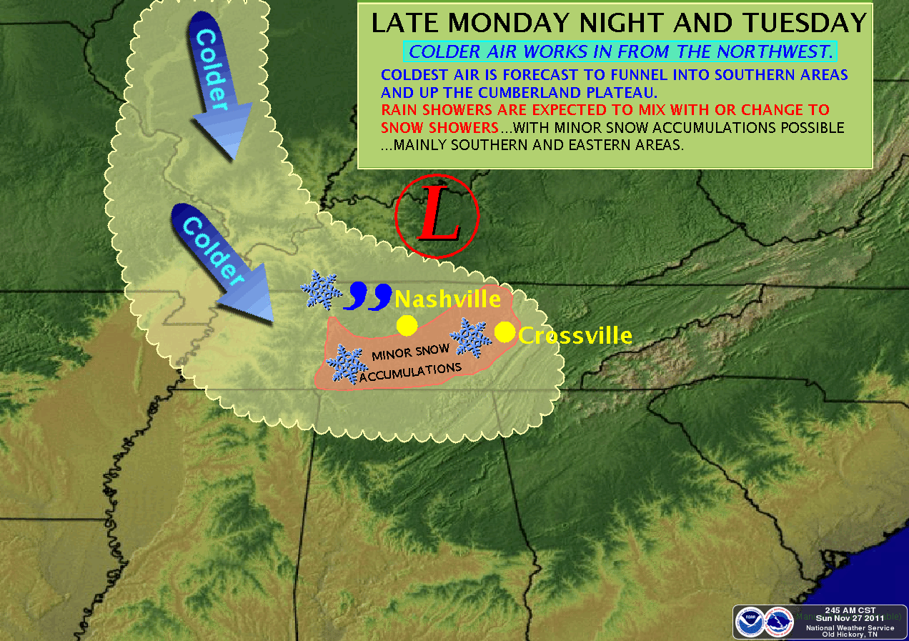
Many of you are wondering about some early week snow chances. I hope to be able to answer some of your questions with this post. Let's first dive into the weather conditions for Sunday night and the forecast for Monday. There will be a Q&A at the end and I will address the Cookeville Christmas Parade.
SUNDAY NIGHT:
Rain continuing, heavy at times, tonight. We've already measured more than 1.25" since rain began before sunrise this morning. I do expect us to receive another 1" to 1.5" before rain ends as snow late on Monday night. Chilly tonight with fairly steady temperatures in the lower to mid 40's (we're at 44.5° just before 7 pm).
MONDAY:
Showers with rain heavy at times. Winds will be fairly calm to 5 mph during the daytime hours and the high should be around 52°. Chance of rain is 100%. Rains continue on Monday night (90% chance) with a low of 37° by morning with snow possibly mixing in before sunrise on Tuesday. A slight chance of accumulation mainly on grassy surfaces.
TUESDAY:
Snow showers before noon then rain shower after noon. A slight chance for accumulation in the morning. He near 43° and winds becoming gusty from the west at 20 mph. A chance of snow for Tuesday night with falling temperatures with a slight chance for accumulation. Lows of around freezing.
Q&A SYNOPSIS:
Q: Do I think we'll have enough snow for hazardous driving conditions?
A: NO, not at this point.
Q: Do I think we'll see schools close early or close entirely this round?
A: NO, I don't believe we'll have enough precip nor will surfaces get cold enough
Q: What about the Cookeville Christmas Parade?
A: The call on postponement will be up to the Cookeville Chamber and if the forecast holds, it appears the parade will go on as scheduled Monday night. Be sure to dress appropriately! (Cold and light rain)
Q: Are we on the borderline for this event and might it miss us?
A: Yes, we are on the borderline and while this event is looking more likely, it is also possible that we may not get any frozen precipitation at all. As of now, it is likely we'll see some white stuff.
Cookeville's 7-Day Forecast
Wet...very wet...then cold...snow chances!
'via Blog this'
Saturday, November 26, 2011
Big Forecast Changes

SNOW CHANCES:
A developing storm system is set to bring a significant amount of rainfall over much of Tennessee for Sunday and Monday. We are looking at between 2 and 3" of precipitation during those two days. Behind the rainmaker is a good chance for OUR FIRST SNOW of the season on Monday night and lingering into Tuesday and Tuesday night.
TODAY:
It's playoff Saturday in Cookeville, TN and the Tennessee Tech Golden Eagles host Central Arkansas this afternoon at 2 pm in Tucker Stadium on the campus of TTU. Expect windy, warm conditions today as our high temperature is expected to reach 66 degrees by kickoff.
Heavy rain expected Sunday and Monday...see the latest, local forecast below!
*Hydrologic Outlook*
*Latest Local Forecast*
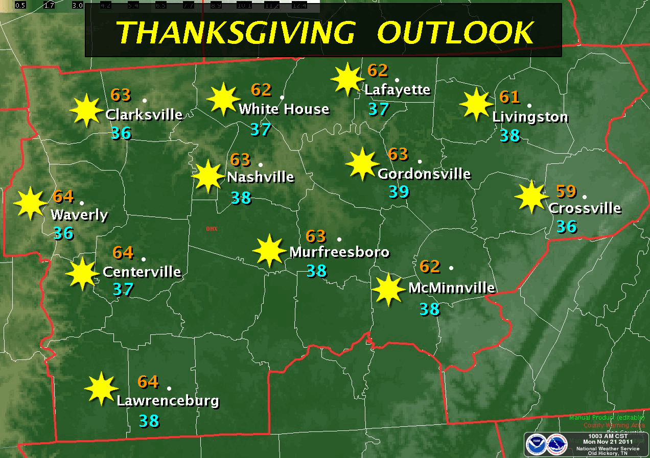
Thursday, November 24, 2011
Black Friday Weather Update

COLDER THAN EXPECTED:
As we head into the overnight hours, expect temperatures to be mainly in the upper 30's through the early morning hours. As of now, the low by sunrise is expected to be 38°, but with calm winds, clear skies and a current 9:45 pm temperature of 38.6°, one can assume the low will be a few more degrees below what was forecast.
BLACK FRIDAY MORNING FORECAST:
So...let's go with 37° at 11 pm on Thursday night
35° by 3 am Friday morning
34° by 6 am Friday morning
FRIDAY and SATURDAY FORECAST:
Temperatures will rise quickly on Friday with sunny skies and a high of 64°. Not as cool on Friday night, low 46° with a slight afternoon chance of showers on playoff Saturday. For the Tennessee Tech football playoff game versus Central Arkansas, I expect cloudy skies by kickoff with a high of 64° and a south wind to 15 mph.
SUNDAY THROUGH TUESDAY:
Here comes the first snow of the season! Much colder on Sunday, high of just 41° and temperatures falling in the afternoon with a rain/snow mix after 4 pm. Snow chances overnight Sunday, low 31°. Partly cloudy and cold on Monday, high just 42°. Another cold night on Monday (Cookeville Christmas Parade) with a low of 31°. Warmer Tuesday with a high of 52° under a sunny sky.
*Latest Local Forecast*
Foggy Thanksgiving Start

SUNNY LATER:
Cookeville is shrouded in fog this morning at 8 am CDT on Thanksgiving 2011. I do expect skies to become sunny as the fog burns off in the next hour or two. Daytime highs will be in the low 60's with a mainly calm wind peaking at 5 mph later in the day. Thanksgiving 2011 night will be clear and cold with lows in the mid 30's by sunrise on Friday. I'll have the forecast for the Black Friday shoppers in the next paragraph.
BLACK FRIDAY SHOPPER FORECAST:
For those early black Friday shoppers, expect the 11 pm temperature to be around 44°. If you're going to one of the 3 am store openings, expect the temperature to be right around 39°. Finally, the just before sunrise temperature will be around 36° (in the 6:00 am range). You'll notice a quick warm-up on Friday with temperatures rising through the 40's in the morning by 9 am and through the 50's by noon. Our high should hit 65° by later in the afternoon.
THANKSGIVING WEEKEND FORECAST:
Tennessee Tech hosts Central Arkansas on Saturday at 2 pm at Tucker Stadium on the campus of TTU in the first-round of the FCS (formerly known as 1-AA) playoffs. I do expect the rain to hold off for the ballgame and for us to have a very nice day at kickoff with a temperature in the middle 60's. Bring a jacket as it will be windy with gusts to 25 mph and sustained winds around 12 to 17 mph. GO TECH!!!!
Tuesday, November 22, 2011
Severe Weather Possible Today
Did you hear about SNOW in the forecast? See last night's post!

Showers and storms are possible for your Tuesday with some storms becoming severe. High around 72°. I don't expect any severe weather until later in the afternoon. It'll be windy with gusts to near 30 mph today. The severe chances continue tonight with an eventual low of 48° by Wednesday morning.
*Hazardous Outlook For Next 7 Days*
We're still going with sunny skies and a cool start to Thanksgiving. Morning temps will be in the 30's but by the afternoon, highs will reach 63°. For Black Friday morning shoppers, you should see your early morning temperatures around 40°, so bundle up!
*Latest Local Forecast*
Monday, November 21, 2011
Stormy Tuesday Setup
**SNOW IN THE FORECAST** More on that below....
---------------
Looking at a challenging weather day across Tennessee on Tuesday as a cold front will be the culprit which causes the possibility of strong storms, including damaging winds, isolated tornadoes, and large hail. Timing for bad weather will certainly be geared toward the later hours in the day for the Cookeville area and earlier in the day further west toward Nashville. Storms will also rumble in the evening hours here in the Upper Cumberland. I would certainly stay WEATHER AWARE all day long. Looks like, though, we should remain fairly quiet during the first part of Tuesday.

The Thanksgiving Day forecast is going to be one that I think most of you will like. Chilly to start in the morning (good for you hunters) but warming during the afternoon to just above 60° with sunny skies! I call that a good day.
Ok, I've saved the snow part for last. Here is the short version. During the upcoming weekend, we see another strong cold front marching through Tennessee bringing some of the coldest air thus far of the fall season. It appears that it'll affect our weather both Saturday and Sunday. By later Sunday night and Monday, enough cold air will be in place to give us a chance for snow showers. By no means am I expecting any accumulation at this point, however, this system bears watching for now. STAY TUNED!!
Speaking of snow, this is an interesting READ on what this winter could be like! Take note of the last two graphics and the thoughts about Siberian snow in October related to possible colder weather east of the Mississippi during the winter.
Storm Monday
You're probably waking up to rumbles of thunder this morning across middle Tennessee. Rain, heavy at times, with an occasional thunderstorm. Some storms may produce gusty winds on your Monday with a high of 69°. Chance of rain today is 90%
*Hazardous Weather Outlook*
*Latest Local Forecast*
Rain chances continue overnight on Monday with a low around 59°. Showers and thunderstorms for Tuesday with some storms possibly becoming severe and producing heavy rainfall. High near 71° and winds running from 10 to 20 mph with gusts to 30 mph. It is possible that reports from trained spotters may be necessary.
I expect our rain gauges to get anywhere from 1" to 2" by the time this system clears our area.
As of now, Thanksgiving looks great with a high of 61° under a sunny sky!
Sunday, November 20, 2011
Storms Developing for Monday and Tuesday
SUNDAY NIGHT UPDATE:
We have received just over two-tenths (or .22") of rainfall on Sunday as of 7:15 pm. The expectation is for the showers to be of an isolated variety overnight. The temperature will only drop a few more degrees to around 59° overnight. Numerous showers and thunderstorms are expected to develop throughout the day across middle Tennessee on Monday and into Monday night. Expect warm days on Monday (69°) and on Tuesday (71°) where we could see some stronger storms develop as warm and cool air masses will collide.
*Latest Local Radar Loop from Nat'l Weather Service*
Early Thanksgiving forecast is for sunny skies and a high of 60 degrees after chilly morning lows in the 30's.
Much more information coming up in the Monday morning update.
*Latest Local Forecast*
Saturday, November 19, 2011
OVC Championship Saturday
FORECAST UPDATE:
With temperatures already climbing to 60° as of 11:00 am, we'll tweak the high up to 64° for this afternoon. Winds are consistent in the 10-15 mph range and have already gusted to 25 mph. I expect that to continue throughout the afternoon hours with possible gusts to 30 mph.

LET'S GO TECH!
The day has finally arrived! The Tennessee Tech Golden Eagle football team hosts Austin Peay State University and with a win, TTU will claim their first Ohio Valley Conference football championship in 36 years and a trip to the FCS playoffs!
SATURDAY WEATHER FORECAST:
The weather forecast couldn't be nicer for championship Saturday as we expect temperatures to be around 60 today with winds steady at 10 to 15 mph with gusts to 20 mph.
RIGHT ABOUT NORMAL:
Today's expected high is right around the normal. Hard to believe we're already two-thirds of the way through November. Temperatures for the month thus far are averaging 50.2°, which is .2° above normal. Rainfall is near normal as well.
Cookeville's Daily Almanac
Our morning low: 44.5°
Yesterday's high: 58.2°
Yesterday's low: 24.7°
Last Year: 59° and 40°
Normal High: 59°
Normal Low: 35°
Records: 78° in 1942 and 15° in 1959
Friday, November 18, 2011
Frosty Morning
Temperatures went down to 24° earlier this morning. We currently stand at 27.5° right now at 6:30 am. Expect a high today of 54° under a sunny sky. We'll stay clear overnight with lows around freezing by Saturday morning and do expect Saturday's high to reach 58° as winds will pick up during the afternoon hours.
Rain returns Sunday through Wednesday with warmer temperatures.
It's cold out this morning...bundle up and leave a little earlier than normal to warm up your car and knock off the frost!
*Latest Local Forecast*
Rain returns Sunday through Wednesday with warmer temperatures.
It's cold out this morning...bundle up and leave a little earlier than normal to warm up your car and knock off the frost!
*Latest Local Forecast*
Thursday, November 17, 2011
Extra Blanket Alert
Very cold night expected across Cookeville and the Upper Cumberland region of Tennessee.
*Latest Local Forecast*
- Expect temperatures to bottom out at 23° by sunrise.
- We're standing at 33° at 6:45 pm, so expect another 10° or so drop by morning.
- You'll need to allow extra time for your car to warm.
- Don't forget the frost from your windows.
- Finally, bundle up the kids in the morning.
Afternoon highs on Friday will feel warm, but we'll only top out in the middle 50's. Those temps will feel warm since we only made it to the mid 40's today. (46.3° at just after 12 noon)
*Latest Local Forecast*
Back Into The Deep Freeze

Tonight, clear...cold...no, very cold....low 24° by sunrise on Friday.
Friday...Sunshine and a high of 52°....chilly again on Friday night...low 33°
Saturday....Beautiful sunshine...high 59°
Next rain chances return on Sunday.
Remember that on Saturday, Tennessee Tech University hosts Austin Peay in football. With a victory, Tech will be the Ohio Valley Conference football champions for the first time since 1975. Make plans now to attend...get to the tailgate park early...TTU is expecting a huge crowd since this is the most important game in 36 years for Tech football. Tickets can be purchased by calling the Athletics Ticket Office at 931-372-3940.
*Latest Local Forecast*
Tuesday, November 15, 2011
The Rain Has Arrived
Quite a bit of moisture is in place and we expect most of today to be a wash-out and all of tonight and Wednesday to be as well. We could see as much as 2" of rain out of this weather system. *RADAR*
36-Hour Quickie Forecast:
80% shower chances for Tuesday, high of 68°
100% chance of showers with possibly a thunderstorm, low 55° on Tuesday night
100% chance of showers with possibly a thunderstorm, high of 58° on Wednesday
20% chance of showers, low 36° on Wednesday night
REST OF WEEK:
Chilly weather on tap for Thursday with sunshine and a high of just 50°. A warming trend appears for Friday through Sunday!
*Latest Local Forecast*
This is Winter Weather Awareness Week across Tennessee!
Winter Weather events may cause short-lived travel problems. However, Tennessee has experienced more significant winter storms in the past, such as:
- 1993 "Storm of the Century": Storm of the Century brings heavy snow to the Cumberland Plateau. Crossville sets a station record with an 18" accumulation. Allardt sets its own one-day snowfall record, with 14.1", as well as Winchester, with 10½".
- 2003 January Winter Storm: A major snowstorm strikes the mid state, with Nashville reporting 7" of snow -- much more than was forecast -- becoming the city's biggest snowfall in nearly 7 years. The snow begins falling around 8:00 a.m., and by mid-day the city is paralyzed with blocked interstates, numerous accidents, and large-scale gridlock.
- 1988 January Winter Storm: A snowstorm brings widespread accumulation to the mid state. Some snowfall totals include Lawrenceburg, with 10", Nashville, 8.1", and Crossville, 6".
- 2011 January 10 Winter Storm: 8 to 12 inches of snow falls over parts of Giles, Lawrence and Marshall Counties.
- January 1918 New Year's Storm: Dickson receives its greatest snowstorm ever, with an accumulation of 15".
Tennessee does experience winter weather--and now is the perfect time of the year to check your winter preparedness plans.
- Make sure your NOAA Weather Radio has fresh batteries in it.
- Make sure you have a means of receiving winter weather information, and be prepared in case you have no way to travel.
- If you must travel in winter weather, be sure to have a Winter Weather Preparedness Kit in your vehicle.
- An ideal Winter Weather Preparedness Kit should include the following:
- A mobile phone (and charger), batteries, blankets, sleeping bags, a first aid kit, a knife, plenty of high calorie non-perishable food items, extra clothing, waterproof matches, sand or cat litter for traction, a shovel, a windshield scraper and brush, a tool kit, a tow rope, battery jumper cables, water containers, road maps and GPS equipment.
- An ideal Winter Weather Preparedness Kit should include the following:
Monday, November 14, 2011
Rain, Heavy at Times, Through Wednesday

Looks like our rain gauges will get a good workout. A chance for rain tonight through Wednesday, then cooler and sunny late in the week.
We have a windy and cloudy Monday on tap for the Highlands area of Tennessee. Only about a 20% chance of showers today but winds will gust to 25 mph. High expected near 71° this afternoon.
Tonight, showers likely and possibly a thunderstorm. A stalled frontal boundary is the culprit. This will cause the rain to stick with us for a few days. Low tonight 61° and rain chances are 70%.
Tuesday, showers continue with a high near 70° and rain chances are 60%. Rains, heavy at times, on Tuesday night with a low of 56°. Rain chances 90%. Can't rule out isolated pockets of heavy rains across Tennessee.
Sunday, November 13, 2011
Windy Sunday


Warm today with mostly cloudy skies. We'll reach 66° this afternoon in Cookeville with warmer temperatures to our west and slightly cooler temperatures in the higher elevations around Monterey, Jamestown, and Crossville. Since midnight, we've seen the highest wind gust of 24 mph at 5:53 this morning. Expect those winds to increase as we move toward the afternoon hours.
For Monday through mid-week, expect rain to develop and we may see upwards of an inch or more through Wednesday with the heaviest likely on Monday night and Tuesday.
PACK THE HOUSE ALERT:
Tennessee Tech University plays for an OVC league title in football this upcoming Saturday. Lets get out and support the Golden Eagles. As of now, the forecast for Saturday, November 19th, 2011 is expected to be mostly sunny with a high temperature of 60°.
Saturday, November 12, 2011
Wind Advisory for Sunday
Strong winds will become even stronger on Sunday. See link below for details from the National Weather Service.
Sunny and Windy
A nice Saturday ahead for Cookeville, TN and vicinity. We will rise to the lower 60's later today under sunny skies. I do expect winds to pick up with gusts to 30 mph.
Temperatures at just after 7:30 am are already near 50.
Expect a similar day on Sunday with a few more clouds, a little warmer (mid 60's) and even windier conditions.
Friday, November 11, 2011
Cold Start...Nice Day Ahead
23 degrees to start this Friday morning. Remember that today is Veteran's Day. Go out and thank a Vet for their service to our country. We are free and secure in the USA due to their service and sacrifice.
Expect a high today of 52 degrees under a sunny sky.
The weekend features a warming trend into the 60's.
Wednesday, November 9, 2011
Showers This Morning

STRONG, GUSTY WINDS:
Best chances for rain for today will be during the morning hours. As of now, the showers are spotty and not all of us will receive rain. Southerly winds will be 10 to 15 mph with gusts to 25 mph. We've already seen gusts to 21 mph earlier this morning around sunrise. Chance of rain is 70%. Expect highs to top out around 65° before backing off. Overnight tonight, much cooler with clearing skies and a low of 36° by sunrise on the Thursday.
NEXT FEW DAYS:
Sunshine returns with much cooler temperatures as Thursday's high struggles to reach 50°. For Friday, Veteran's Day (11-11-11), our high will be 53° after a morning low of 28° and then sunny again for Saturday, high of 60°.
VETERANS DAY:
Coming up on 11-11-11 is Veterans Day. It is the anniversary of the signing of the Armistice that ended World War I and was formally signed at the 11th hour on the 11th day of the 11th month in 1918 (more on Veterans Day here). We honor our veterans each year on 11-11. Please take time to thank a vet for their service to our country. Without them and their sacrifice, we wouldn't have the great freedoms we enjoy today.
Tuesday, November 8, 2011
Nice Tuesday Forecast
SUNNY SKIES:
Quite a nice day ahead for those of us living in the Cookeville, TN and vicinity areas. Look for a mostly sunny sky with highs eventually reaching around 71° (about the same as on Monday). We start out in the mid 50's after a morning low of 51°. A very slight chance for rain tonight, low 52°. Rain chances about 20% late.
RAIN RETURNS:
Wednesday's forecast is an interesting one. Should see some rain (and the reason I say 'should' is that not all of us in the eastern sections of middle TN will) by the afternoon hours with a slight chance of a thunderstorm. Highs will be only in the lower 60's. Wednesday night will see the rain move out and a low of 36°.
EXTENDED OUTLOOK:
Chilly, but sunny Thursday with highs only reaching 50° (some will stay in the 40's). Freezing temperatures on Thursday night, low 28° with sunshine on Friday, high 52°. The weekend looks nice with highs in the upper 50's on Saturday and lower 60's on Sunday with clouds returning.
STANDARD TIME:
I sure do enjoy the morning's being light once again when I awake, but this getting dark at 5:00 pm (tonight's sunset is 4:40 pm) will take a little getting used to over the next couple of days or so.
*Latest Local Forecast*
Sunday, November 6, 2011
Sunny Sunday

Another wonderful autumn on tap for those of us in the Highlands of Tennessee. In fact all of the Volunteer State will see this beautiful weather. We'll stick with sunny skies all the way through Tuesday with highs in the upper 60's.
Rain returns Wednesday and much cooler temperatures for the end of the upcoming week.
*Latest Local Forecast*
Saturday, November 5, 2011
Sunny Weekend Ahead

Areas of fog will burn off this morning across much of the Highlands of Tennessee and we expect sunny skies and a nice warm up today. Highs will be around 62° for the Cookeville area and slightly cooler on the plateau near Monterey, Jamestown, and Clarkrange.
SUPER SATURDAY FUN:
Don't forget...it is TTU Homecoming Weekend with the TTU Homecoming Parade starting at 10:30 this morning and the Homecoming Football contest this afternoon at 1:30 at Tucker Stadium. Your league leading Golden Eagles host Murray State. Tech is also ranked 15th in the nation in the latest Coach's Poll.
FALL BACK TONIGHT:
Overnight on Saturday, don't forget to 'FALL BACK', that is to turn your clocks back one hour before heading to bed tonight. Otherwise, you'll be early to church Sunday morning. (of course, that would be a first for some!)
Speaking of Sunday, morning temperatures just after sunrise will be in the mid to upper 30's and we'll see another sunny day with highs reaching 63°.
THE WEEK AHEAD:
Monday and Tuesday will feature sunny skies and highs between 68° and 70° both days. Rain is expected to re-appear by mid-week with the possibility of thunderstorms. We'll watch that closely.
*Latest Local Forecast*
Super Foggy Saturday Morning

Thick fog has enveloped much of middle Tennessee this morning. The cause is clear skies with light winds and abundant moisture near the surface. Visibilities have been reduced to one-quarter mile or less in many locations.
Obviously, you'll want to slow down, use your headlights on LOW BEAM, and be sure to leave plenty of distance between you and the car ahead.
*Dense Fog Advisory*
*Latest Local Forecast*
Tuesday, November 1, 2011
Super Nice Tuesday

COLD START:
If you've ventured outdoors this morning, you'll definitely notice a nip in the air. The low was 31.5° at just before sunrise. We're hanging around freezing (32°) just after sun up and anticipate temperatures will rise quickly this morning. Highs this afternoon will be in the middle 60's with calm winds and sunny skies.
WARM WEDNESDAY:
Another cold overnight tonight with lows of around 40° by sunrise Wednesday and a high of 68° Wednesday afternoon. Clear and cool Wednesday night with lows of 44° and rain moves in for Thursday and Thursday night with a high of 57° and a low of 43°. Rain chances 70% on Thursday and just 20% Thursday night.
OCTOBER BY THE #'s
Avg. High: 69.3° (Normal: 71.2°) (Record: 77.4 in 1938)
Avg. Low: 41.7° (Normal: 44.0°) (Record: 34.7 in 1987)
Rainfall: 4.03" (Normal: 3.21") (Record: 11.15" in 1919)
High: 84.3 on 10/6
Low: 28.9 on 10/30
Wind gust: 25 mph on 10/14/11
Subscribe to:
Posts (Atom)
AMS
Member-American Meteorological Society