Showing posts with label cold. Show all posts

Sunday, January 26, 2014

Here Comes The Cold (Again)

Snow showers develop after 3 am as winds turn to the north northwest after frontal passage. Gusts could be as high as 20 mph. Some locations will see as much as one-half inch of accumulation by morning. Low temperature by sunrise of 22°.


WEAR COAT, GLOVES, AND SCARF MONDAY AND TUESDAY

MONDAY'S VERY COLD FORECAST:
20% chance of snow before noon under a cloudy sky with falling temperatures all day. Not expecting any additional accumulation. Gusty winds up to 25 mph will make the day feel quick cutting on exposed skin. Expect temps around 5 pm to be in the middle teens.

BRUTAL COLD ONCE AGAIN:
On Monday night, a wind chill advisory is in effect for below zero wind chill readings from midnight through noon on Tuesday. Very cold with a low of 8°. A high of 19° is expected on Tuesday with sunny skies.


**WIND CHILL ADVISORY**

Tuesday night will be very cold once again with a low of 5°. With any snow cover, we may end up even colder but winds will die down.

Wednesday will see warmer temps with a high of 28°.

We'll probably end up around 82 hours or so below freezing after a 90+ hour run last week. Thursday will finally see us break out from freezing and get up to 41°.

The warm-up continues through the weekend with possible highs in the 50's both Saturday and Sunday! Don't get too comfortable as winter still has a ways to go.

*Latest Local Forecast*


Interact with me on social media:


Monday, January 20, 2014

Gorgeous Monday, But......


Get out and enjoy this unseasonably warm weather today (Monday) across the Cookeville area. We'll be in the mid 50's this afternoon under plenty of sunshine. Winds will be fairly light making the day feel quite comfortable.

****SPECIAL WEATHER STATEMENT****


TUESDAY SNOW POSSIBLE:
Tonight, clouds increase and we'll drop into the lower 30's by morning. A very strong Arctic cold front will usher in cold temps and strong north northwesterly winds. I expect temperatures to fall most of the afternoon on Tuesday. We can't rule out a period of snow showers on Tuesday with possible accumulations. Expect lows by Wednesday morning to be in the single digits.

LONG PERIOD BELOW FREEZING:
As of now it appears we will be below freezing in Cookeville from 7 am on Tuesday all the way through Saturday at noon. You'll want to make sure your pipes are protected from freezing and your pets are either brought indoors or have adequate protection from the cold.

SECOND ROUND OF COLD:
A reinforcement shot of cold air arrives on Thursday with Friday morning's lows again in the single digits.

THE WEEKEND AHEAD:
As of now, the upcoming weekend is expected to be above freezing with high temps around 40° both days. This is well below normal of 47° for our daytime average high and 26° for our average nighttime low.

DID YOU KNOW:
Our average coldest week of the year is typically the third week of January?
January's temps are running about 3° BELOW normal for the high and 6° BELOW normal for the low?

APPS OF THE DAY:
I have two weather apps today that I'd like to see you try.

WEATHER UNDERGROUND:
for Android
for iOS

PWS MONITOR:
Only available for iOS devices for now


*Latest Local Forecast*


Interact with me on social media:


Sunday, January 19, 2014

SUNDAY UPDATE: Cold Air Coming Back Next Week

Has January been cold enough for you? 

I counted up the number of +50° days and believe it or not, we have had 7 of them thus far in January.

That being said, our average high temperature is just 43° and our average low is 19°.

Normals are 46° and 26° for January. It has been COLD.

Speaking of cold, it returns with a vengeance once again beginning Tuesday. Looks like highs in the upper 20's and lower 30's with lows in the teens. There is a slight chance we may even drop into the single digits on Wednesday morning.

I know everyone wants a 'big' snow. Nothing so far YET!

Stay tuned!

*Latest Local Forecast*


Interact with me on social media:


Sunday, December 22, 2013

Down Go The Temperatures (Christmas Eve and Christmas Day)

Quite a night last evening with the sheer number of watches/warnings. The weather radio got quite a workout. It is, by the way, a great Christmas gift idea.

DID YOU KNOW IS BACK and is below!

STORM REPORTS:
Here is a preliminary list of storm reports from across Middle TN.

I have your Christmas Eve and Christmas Day forecast below, it'll feel a lot like Christmas!

VERY HEAVY RAINFALL OVERNIGHT:
Here at my weather station live, we recorded 2.03" of rainfall during this system with all of it but .10" falling during the height of the storm late last night and early this morning.

Looking at Wundermap from Weather Underground, we see cooler temperatures back to our northwest poised to make themselves felt in our area.

FORECAST FOR TODAY AND MONDAY:
We'll see a slight chance for showers today and tonight. It'll be the last warm day for a while with temperatures around the current 57° for today's high. We'll be down to 34° tonight and just in the low 40's on Monday.


SHORT-LIVED BUT BRUTAL COLD AHEAD:
Temperatures plummet for Monday night and Tuesday. We'll struggle to make it to 30° on Tuesday under a clear sky. Now that is Christmas Eve weather! Very cold overnight Christmas Eve and on Christmas morning with lows around 18°. Expect highs in the lower 40's for Christmas Day with sunshine.

DID YOU KNOW:
A) We hit 73° for a high on Saturday (record: 74° in 1998)
B) Only 3 recorded tornadoes in Middle TN since 1950
C) WUndermap is what I use for radar - Check it out here


*Latest Local Forecast*


Interact with me on social media:


Sunday, November 24, 2013

Possible Snow and Special Weather Statement for Tuesday Night

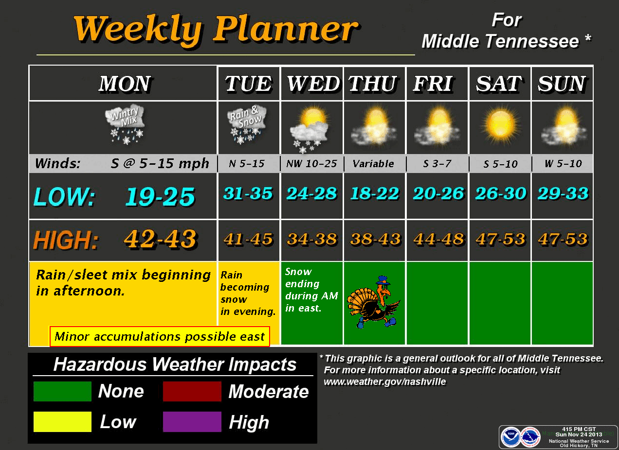
We are stuck in a cold pattern across the mid-south including the middle Tennessee area. There is a Special Weather Statement (see below) for Tuesday night for possible accumulating snow and I expect we will also see a wind advisory issued at some point.

Sunday's high of 32° was 25° BELOW NORMAL in Cookeville.

TONIGHT AND MONDAY:
Expect another cold night with temps dropping to around 22° after midnight but then gradually rise with increasing clouds. Monday will see the clouds continue to increase with a high of 44°. Calm wind to start but becoming southerly around 5 mph.

HERE IS WHERE IT BECOMES COMPLICATED:
A 50/50 chance of rain and sleet on Monday night.
Little or no snow accumulation expected with a low of 33°.

We'll see this mix continue on Tuesday morning but turn to all rain during the mid-morning hours with a high of 43°.

TUESDAY NIGHT SNOW CHANCES:
On Tuesday night, rain turns to a rain/snow mix in the evening and then to all snow after midnight. The low is expected to be around 27° with gusty north winds from 15 to 25 mph. Chance of snow is 50% and some accumulation is possible in higher elevations.

For Wednesday, a chance of snow in the morning and a high of 37° in the afternoon, but it'll be bitterly raw with winds running to 35 mph in gusts. Cold Wednesday night with a low of 21° by Thanksgiving morning.

Expect sunshine and 40° on Thanksgiving Day.


Special Weather Statement

*Latest Local Forecast*


Interact with me on social media:

Wednesday, November 13, 2013

Coldest Morning of The Season


After seeing snow showers on Tuesday, we start Wednesday morning at just 18.5°. The last time it was this cold was back on February 17th. That is a span of 9 months or 270 days. For those of you wondering where this morning's low compares, the record for this date is 15°, which occurred back in 1920. A record that has stood for 93 years.

CHILLY TODAY; WARMER TOMORROW:
I do expect us to go up to the mid 40's today (44°) for the high temperature under sunny skies. It'll feel warmer due to the sunshine and light winds. We will have another cold night across the region and expect lows to drop to the middle 20's. For Thursday, we'll repeat today's forecast with sunny skies but add about 11° to the forecasted high as we'll hit 55°.

WEEKEND FORECAST: 
Clouds return on Friday with a high near 60° and rain is expected for the weekend with only a slight chance on Saturday and a better chance on Sunday.

*Latest Local Forecast*


Interact with me on social media:


Monday, July 29, 2013

Very Cool Start To Monday


We start at 53.3° on this Monday morning. It is the coolest morning since May 14th. Record lows have been smashed throughout middle Tennessee this morning. Expect sunny skies and a high of 80° this afternoon with a light north northwest wind of around 5 mph. Increasing clouds overnight and not as cool with a low of 63°.

Mostly cloudy skies on Tuesday with a high of around 82°. Scattered showers and thunderstorms are expected to develop Tuesday night with a low of 67°. Chance of rain is 40%.

A good chance of scattered thunderstorms on Wednesday with a high of 82°.

The rest of the 7-day is below. Enjoy your cool Monday morning and gorgeous Monday!

*Latest Local Forecast*


Interact with me on social media:


Monday, May 13, 2013

Cold Overnight

Everything looks in order tonight for a significant frost event.

Temperatures are sitting at 40.2° just before midnight and I expect we'll drop another 6-8° by sunrise on Monday morning. If you've not covered your flowers or garden items like tomatoes, you still have a bit of time to do that.

*Latest Local Forecast*


Sunday, January 20, 2013

Sunny Sunday with Massive Fall Off Ahead


If you like a little warm weather, get out and enjoy today because you'll not like the next several days as we switch patterns once again. The coldest air YET of the season roars in for Monday night through Wednesday morning.

*Snow and Ice Report for western, middle Tennessee*

Sunday's forecast is for sunny skies and a high of 49°. The winds will switch around to the northwest at around 5 mph but will become calm later in the day. Clear and cold overnight with a low of 27° by Monday morning. Most schools, state, and federal offices will close on Monday (MLK day). Monday's high is expected to be just 38°.

VERY, VERY COLD
Monday night will be mostly cloudy and frigid with a low of 14° by Tuesday morning. As you send the kids out for school, please bundle them up appropriately. Tuesday's high will be just 25° and we'll be bitterly cold once again on Tuesday night with a low of 15° by Wednesday at sunrise. Wednesday's high will warm a bit to 39°.

Further out, we have a slight chance for rain/snow on Thursday and Friday.

*Latest Local Forecast*


Interact with me on social media:
Michael Detwiler on Facebook 
CookevilleWeatherGuy on Facebook
Weather Guy on Twitter
Cookeville Weather Alerts on Twitter
Cookeville Weather Guy on Google +


Saturday, December 29, 2012

Snow Showers Continue

Snow continues to fall lightly over much of the area with heavier bands back to our west. The challenging part of this upper level system is what happens as the sun goes down. My thoughts are that it will begin to cause some travel headaches for areas east of metropolitan Nashville. We've still got several hours of light snow to go AND without the radiant heating of the sun during the daytime, melting will cease after sunset.

As far as accumulation goes, we've got a light dusting at this point and I don't see us getting much more than one-half inch.

*Special Weather Statement*

Rest of this afternoon - Snow showers continue, mainly light with some accumulation mainly on grassy areas, rooftops, and vehicles. Temperatures steady around freezing.

Tonight - Snow showers continue through midnight. Falling temperatures with possibly slick conditions especially on bridges and overpasses along with less-traveled roads. Cloudy but becoming partly cloudy after midnight through daybreak with a low of 20° by sunrise.

Sunday - Sunny skies and very cold, high of just 37°

New Year's Eve and New Year's Day - Rain likely especially on Monday night and Tuesday. The highs both days will be in the mid 40's and the low around 40°.

*Latest Local Forecast*


Interact with me on social media:
Michael Detwiler on Facebook 
CookevilleWeatherGuy on Facebook
Weather Guy on Twitter
Cookeville Weather Alerts on Twitter
Cookeville Weather Guy on Google +


Monday, November 12, 2012

Very Cold Overnight

We're already down to 32° at 9:25 pm. Lows by sunrise will range from 25-27°. Sunshine and a struggle to hit 50° on Tuesday with another night below freezing on Tuesday night/Wednesday morning with highs on Wednesday around 53°. We should be just above freezing for the low on Wednesday and rising to around 57° on Thursday.

No rain chances in the 7-day forecast.

*Latest Local Forecast*


Interact with me on social media:
Weather Guy on Facebook
Weather Guy on Twitter
Cookeville Weather Alerts on Twitter


Sunday, October 28, 2012

Snow, Windy, and Cold

With Hurricane Sandy making big news on the east coast, she is also affecting our weather here in middle TN. Typically in late October our average high is 66°. We'll struggle to get to 50° the next few days. Sandy's counter clockwise motion is pulling cold air in from Canada.

SNOW!
If you like snow, you won't have to go far. In elevations just above Gatlinburg, there is a Winter Storm Warning for 4-12". Blizzard conditions are expected at times.

WINDY!
We'll have windy conditions right here in the Cookeville area and across much of middle TN on Monday, Monday night, Tuesday, and into Wednesday where gusts could hit 30 mph.

COLD!
Expect lows to drop to 35° by Monday morning with some frost, 34° by Tuesday morning, 32° by Wednesday morning. It'll be quite the shock to our system after this nice run of warm weather last week.

*Latest Local Forecast*


Interact with me on social media:
Weather Guy on Facebook
Weather Guy on Twitter
Cookeville Weather Alerts on Twitter


Saturday, February 11, 2012

Middle Tennessee Snow Totals


Here is a look at some snowfall totals from across the area. 

2.5"  Jamestown (Fentress County)
2.4"  Monterey (Putnam County)
2.0"  Allardt (Fentress County)
1.5"  Clarkrange (Fentress County)
1.2"  Livingston (Overton County)
1.0"  Crossville (Cumberland County)
1.0"  Fairfield Glade (Cumberland County)

In Cookeville, measurements have been in the dusting to 2/10ths of 1 inch range. Here are some pictures from my Facebook friends. 

I-40 heading east on Monterey mountain

1800 feet elevation at Monterey

Snow picture last night in Monterey


TODAY'S FORECAST:
Bitterly cold air is in place and we're currently at 23.0° at 11:55 am. Factoring in the gusty north winds, which have been consistently in the 10-15 mph up to 20 mph, the 'feels like' temperatures are in the lower to middle teens this morning. Originally, we thought our high would be 27-30° across the area, but it looks like we'll struggle to make that.


Tuesday, January 3, 2012

Sunshine and Cold

A very cold start this morning across middle Tennessee as we are at 14° at sunrise. Highs later today will fight to reach 30° with sunny skies and a mainly calm wind. Overnight, clear and very cold with a low of 19° by Wednesday morning. Warmer on Wednesday, high of 45° with increasing clouds and winds gusting to 25 mph. Sunny on Thursday and Friday with highs of 50° and 58° respectively. Rain returns on Friday night through the weekend.

A Special Weather Statement is in effect this morning for slippery roads along the upper plateau. Up to 1" of snow fell late in the afternoon on Monday and into Monday night and with temperatures well below freezing, any remaining snow created very slippery conditions, especially on secondary roads. Motorists are urged to use caution during the morning commute.

Schools are closed in several counties on Tuesday, including Putnam, White, Cumberland, Fentress, Jackson, Overton, Pickett, and Van Buren. Schools are delayed by 2 hours in Clay, Grundy, Macon, and Trousdale.


*Latest Local Forecast*


Sunday, January 1, 2012

Strong Front Bringing Cold Air

TEMPS GOING DOWN:
Cold air is poised just to our north associated with a front. Temperatures at the 4 pm hour are mainly in the 50's across Tennessee but readings in the 40's are knocking on our door in Kentucky. Our high hit 58.8° around 6:30 this morning and has been slowly falling (about 1.5° to 2° per hour since 2 pm).

MORE COLD AIR:
A reinforcement of the cold air will occur Monday with blustery conditions (wind gusts to 40 mph) and highs struggling to reach the middle 30's. We can't rule out a chance of snow on Monday night (not excited about the chances nor any shot at accumulation) as lows will drop to the teens by Tuesday morning. The highs Tuesday will struggle to freezing with another bitterly cold night on Tuesday with lows by Wednesday morning around 20°.

WARMING TREND MID-WEEK:
We should moderate mid-week and by Friday the high should be in the middle 50's. Computer forecasting models do show another strong shot at cold air with an associated storm next week and that could bring our first accumulating snowfall of the season. Time will tell.


Friday, December 30, 2011

Big Weather Changes for New Year


NICE 2 DAYS AHEAD:
Gorgeous Friday with a slight chance of rain, high in the upper 50's today across the Upper Cumberland region of Tennessee. We do have a slight chance (only about 20%) for a shower. Partly cloudy tonight with a low of 36° by sunrise on Saturday.

WEEKEND FORECAST:
Saturday is expected to be the best day as we'll see sunny skies and warm temperatures with light winds. The high will be around 57°. Rain returns for Saturday night (New Year's Eve) and New Year's Day on Sunday. The low will be 43° with the high of 49°. Rain chances right now look to be slight, but that could change to a better chance.

HERE COMES THE COLD:
Temperatures will plunge New Year's night as an Arctic cold front ushers in the coldest air this season. Expect 26° by Monday morning and highs will only creep up to 35° with a low on Monday night of 18°.

SCHOOL START FORECAST:
Schools start back across the Highlands of Tennessee on Tuesday and you'll want to bundle up your kids as 7 am temps will be in the higher teens. The high Tuesday is only expected to reach 35°.


Wednesday, October 19, 2011

Huge Temperature Changes


Big temperature drop in middle Tennessee over next several days, but we'll get to that in a moment.

Did you know that today is Tennessee Fall Severe Weather Awareness Day? The secondary peak severe weather season occurs in the fall and winter and historically that has been in November. Because of this, the National Weather Service would like to call attention to this and alert people on this.

Back to the chilly weather. We start this Wednesday morning out in the 40's (44° at post time) and expect highs to struggle to go higher than the 40's this afternoon with cloudy skies and a northwest wind. Tonight, showers probable, low 41° and then chilly again on Thursday with a high of just 51° with winds running 10 to 15 mph with gusts to 25 mph making that high temperature feel quite cold.

Expect frost to develop for Friday and Saturday mornings with lows in the mid 30's and highs on both days from 57° to 63°. Sunday will be the nicest day with a high of 66°

It's jacket time in Tennessee. Have a great day!

*Latest Local Forecast*


Sunday, January 3, 2010

Snow Storm Later This Week?

BRRRRRRRRRR: Downright cold to start your Sunday morning. Temperatures dropped to the single digits in some locations (like Crossville with 8°). Today's highs will struggle to reach the 20's once again. Yesterday's high here in Cookeville was just 22°. We dropped to 10° this morning just after sunrise. For tonight, expect lows to be even colder...around 5-8° here in Cookeville. Think it is cold here, how about going to the Great Smoky Mountains where it is: -5 Newfound Gap, 6 inches of snow and -5 atop Mt. LeConte, 13 inches of snow

SNOW STORM POSSIBILITIES: We're watching the potential of an accumulating snow event later this week. Forecasting models are beginning to get their act together in regards to the potential of this storm. While I don't go out on the limb to predict amounts, etc. I can tell you there is a good chance of accumulations in the 2-5" range should this pan out. For MUCH MORE INFORMATION on this potential storm, check out Justin Bruce's post at NashvilleWX.com.

*Latest Local Forecast*

Weather History for This Date
2000 - A very spring-like day as temps hit 72° in Nashville and 66° in Crossville.

Fun Weather Site of The Day
Go discuss the weather at TennesseeWX.com


Cookeville's Daily Almanac
Yesterday's high: 22° low: 14°
Normal High: 46°
(Record: 70° in 2006)
Normal Low: 26°
(Record: 2° in 1928)
Last Year: 52° and 36°
2.35" of rain fell on this date in 1992
2" of snow in 1942
4" was on the ground in 1919
--------------------------------------------------
Join me on Facebook and request to be my friend.

Follow me on Twitter. It is a great way to keep up quickly!

Read my latest weather post at Examiner.com website, I am the Nashville Weather Examiner.

Saturday, January 2, 2010

Very Cold Overnight

Temperatures are expected to bottom out tonight in lower teens for many of us. At just after midnight, we stand at 18° in Cookeville with a wind-chill reading of 7°. Highs on Saturday are expected to only reach 25° with a cold north-northwest wind.

Lows by sunrise Sunday will be very close to single digits. Just 22° for our high Sunday. Expect the next storm system by mid-week. Temperatures appear, at this time, to be cold enough for this next event to be all snow. We'll see!


Make sure your garden hoses are detached from the faucet and your autos are fully prepared for the cold weather.

Wednesday, January 21, 2009

Cold and Snow Facts (Historical Day)

WEATHER HISTORY
Let's start out with this day in history.
On January 21st, 1985..Cookeville records it's lowest temperature ever as our low drops to -22°....we never go into positive numbers as the high reaches just -8°...


Other record lows on this date in 1985 include
Allardt (-27), 
Carthage (-17), 
Celina (-20), 
Centerville (-26), 
Columbia (-20), 
Cookeville (-22), 
Crossville (-21), 
Crossville (Experiment Station) (-25), 
Dickson (-23), 
Franklin (-21), 
Lebanon (3 W) (-20), 
Lewisburg (-20), 
Livingston (-25), 
Monteagle (-20)
Mount Pleasant (-17), 
Neapolis (-23), 
Shelbyville (-20), 
Smithville (-24), 
Woodbury (-28). 

SNOWFALL AROUND TENNESSEE
I've been looking over some snowfall amounts in Tennessee and found the following measurements.  Mount LeConte has 9", other locations in the Smokies are: Sugarlands Visitor Center has 3", Newfound Gap  and Cades Cove both with 4".  Erwin in Unicoi County is reporting 6", while Washburn in Grainger County has 2.6".  Here in Cookeville, we have 1" and a station just to our east in Monterey has 1.8"....

AMS

AMS
Member-American Meteorological Society