Showing posts with label extended forecast. Show all posts

Tuesday, August 19, 2014

Hottest Temps of 2014 This Weekend

The headlines are to expect temps hitting the mid 90's in the Cookeville area starting Thursday through the weekend. A slight chance for a garden variety summer time thunderstorm.

We hit 87° on Tuesday which is the warmest day since last Monday, August 11th. Expect temps in the low 90's for Wednesday and around 94-95° for Thursday, Friday, Saturday, and Sunday. We may even be underplaying the high temps a bit, so upper 90's are a possibility with 100° highs to the west of Nashville.

Both June and July saw days where our high hit 93°, Highs over the next few days will exceed that temp.

With today's rains, August has topped 4". 

*Latest Local Forecast*


Interact with me on social media:
Weather Guy on Facebook
Weather Guy on Twitter
Cookeville Weather Alerts on Twitter
Cookeville Weather Guy on Google +

Sunday, August 17, 2014

Sunday Storms and Upcoming Week's Forecast

Looking at the latest radar loop you can see more storms developing over middle TN and even more streaming eastward from western sections of TN.  

In Cookeville, we've already recorded more than .50 (half inch) of rainfall and isolated locations could see as much as 2-4 inches before the rain moves out on Monday evening. 

Strong storms are possible, but I believe they will stay under the severe limits. We do, however, believe that locally heavy rainfall will occur.

With cloud cover today, temps won't warm much and will be in the mid 80's on Monday. The rest of the week will see temps approach 90° all the way through the upcoming weekend. 

*Latest Local Forecast*


Interact with me on social media:
Weather Guy on Facebook
Weather Guy on Twitter
Cookeville Weather Alerts on Twitter
Cookeville Weather Guy on Google +

Monday, August 4, 2014

Cool Nights, Warm Days


Nice August Start:
Our run of cool evenings continue during the first several days of August. So far lows have mainly around 60° with 58.2° recorded this morning. Average low temps are 65° this time of year. We are off to another below normal month for August as the average temperature is already 4° below normal. This afternoon's high in Cookeville was 86.6°.

48-Hour Forecast:
Tonight: Clear, low 58°
Tuesday: Sunny, high 88°
Tuesday night: Clear, low 61°
Wednesday: 30% thunderstorms, high 91°

Extended Forecast:
Expect thunderstorm chances to increase for both Thursday and Friday with highs in the mid to upper 80's. Rain chances are great than 50%. Lower chances for rain this upcoming weekend with highs in the mid 80's and lows in the mid to upper 60's.

Air Quality Alert for Nashville Metro area and surrounding counties.
Areas to our west are under an Air Quality Alert issued by the Tennessee Department of Environment and Conservation from midnight tonight (Monday) through midnight on Tuesday night. Persons with respiratory disease such as asthma should limit prolonged exposure in the alert areas. The general public is not likely affected by this alert.

Tonight's Links:
3-month forecast for September through November
Latest info on Hurricane Bertha

*Latest Local Forecast*


Interact with me on social media:
Weather Guy on Facebook
Weather Guy on Twitter
Cookeville Weather Alerts on Twitter
Cookeville Weather Guy on Google +

Sunday, July 20, 2014

Summer Makes It's Return

I'm sure you've noticed the increase warmth today (Sunday) across the area. We've been as warm as 85° this afternoon. Some have seen a few stray showers and thunderstorms, but nothing compared to the coverage of showers the last two days.

WINTER OUTLOOK MAP:

The guys at http://firsthandweather.com/ have released a preliminary 2014-2015 winter forecast and it shows areas east of the Rockies with a winter of well below normal temps and average to above average rain/snow. I'm sure some teachers and students will love this prediction.

COLD JULY TEMPS
Speaking of cool weather, check out a couple of stories from The Weather Channel about the July record cold snap. It was one of the strongest ones ever recorded.
The Coldest July Days Ever
July Chill Brought Record Cold Temps


REST OF WEEK FORECAST:
We've returned to summer with warm temps and slight chances of afternoon thunderstorms. All the information is located in the link below.

*Latest Local Forecast*


Interact with me on social media:
Weather Guy on Facebook
Weather Guy on Twitter
Cookeville Weather Alerts on Twitter
Find me on Google+

Saturday, July 19, 2014

Like Living in Seattle But Changes Are Ahead


Tired of the rain? I've got bad news for you!

Looks like this first round will wrap up this morning, but a second round will be on their way later this afternoon. Thundershowers will only be very isolated in our area with highs just in the mid 70's (about 15°-20° below normal).

COOKEVILLE BY THE NUMBERS:

  • 1.70" of rain recorded in last 24 hours (almost a record breaker for this date)
  • Friday's high was just 68.8° which breaks a record from 2009 for the coolest high temperature recorded in Cookeville, TN on that date by 3°.
  • 53° was the coldest low temp on record, by the way, on Thursday morning! 


SUNDAY AND THE WEEK AHEAD:
Sunday's forecast calls for a slight chance of a thunderstorm with a high of 83°. The week ahead promises a more summer type pattern with slight afternoon thunderstorm chances and highs in the upper 80's.


The end of next and the weekend just might be sunny, warm, and include no rain!

WEATHER LINK OF THE DAY:
Today's link includes an interesting graphics page from the National Weather Service in Nashville. More information than you can digest!
http://graphical.weather.gov/sectors/ohx.php

*Latest Local Forecast*


Interact with me on social media:
Weather Guy on Facebook
Weather Guy on Twitter
Cookeville Weather Alerts on Twitter
Find me on Google+


Monday, January 20, 2014

Gorgeous Monday, But......


Get out and enjoy this unseasonably warm weather today (Monday) across the Cookeville area. We'll be in the mid 50's this afternoon under plenty of sunshine. Winds will be fairly light making the day feel quite comfortable.

****SPECIAL WEATHER STATEMENT****


TUESDAY SNOW POSSIBLE:
Tonight, clouds increase and we'll drop into the lower 30's by morning. A very strong Arctic cold front will usher in cold temps and strong north northwesterly winds. I expect temperatures to fall most of the afternoon on Tuesday. We can't rule out a period of snow showers on Tuesday with possible accumulations. Expect lows by Wednesday morning to be in the single digits.

LONG PERIOD BELOW FREEZING:
As of now it appears we will be below freezing in Cookeville from 7 am on Tuesday all the way through Saturday at noon. You'll want to make sure your pipes are protected from freezing and your pets are either brought indoors or have adequate protection from the cold.

SECOND ROUND OF COLD:
A reinforcement shot of cold air arrives on Thursday with Friday morning's lows again in the single digits.

THE WEEKEND AHEAD:
As of now, the upcoming weekend is expected to be above freezing with high temps around 40° both days. This is well below normal of 47° for our daytime average high and 26° for our average nighttime low.

DID YOU KNOW:
Our average coldest week of the year is typically the third week of January?
January's temps are running about 3° BELOW normal for the high and 6° BELOW normal for the low?

APPS OF THE DAY:
I have two weather apps today that I'd like to see you try.

WEATHER UNDERGROUND:
for Android
for iOS

PWS MONITOR:
Only available for iOS devices for now


*Latest Local Forecast*


Interact with me on social media:


Sunday, August 25, 2013

The Heat Has Returned

We have to go all the way back to last year to see a run of hot days like we've had the past two days and expect to have the next 7 days.

I believe we'll top 88° (and even into the 90's) during the next 7-day period. We did have a 7-day period in July where that was the case, but this appears to be at least 9-10 days in length. Expect hot weather all the way through next weekend with only a limited chance for rain.

Sunday - 88°
Monday - 89°
Tuesday - 90°
Wednesday - 91°
Thursday - 90°
Friday - 90°
Saturday - 90°
Sunday - 90°

I expect a slight chance for showers on Thursday - Sunday.

The summer that wasn't has returned!

*Latest Local Forecast*


Interact with me on social media:


Sunday, August 11, 2013

Quiet Sunday Evening But Busy Monday


Expect a fairly quiet Sunday night as temperatures will drop to around 70° by morning. It'll be fairly muggy as dew points are still in the lower 70's. Thunderstorms are likely on Monday (about a 60% chance) with a high of 84° and light WNW winds. A 50% chance of thunderstorms for Monday night and a low of 69°.

BEYOND MONDAY:
Expect another great chance for showers and thunderstorms on both Tuesday and Tuesday night with high of 84° and a low of 64°. Once we get past Tuesday I do believe we'll see much more settled and more comfortable weather. Lower 80's for Wednesday, Thursday, and Friday with lows in the lower 60's for those nights. Looks like a fairly comfortable weekend ahead.

*Latest Local Forecast*


Sunday, August 11th Facts and Figures:

Hottest Temperature (worldwide): 113.0° in Najaf, Iraq
Coldest Temperature (worldwide): -63° in Amundsen-Scott, Antarctica

Corona, California: 48° breaking their old record of 54° set in 2009.
Corona is about 1 hour east-southeast of Los Angeles.

Dallas, GA in Paulding County recorded 3.74" to claim the wettest spot in America today.


Interact with me on social media:


Sunday, July 14, 2013

Thunderstorms Likely - Sharknado - Baseball's All-Star Game

All sorts of interesting weather information today. We'll get into why the popular TV movie Sharknado is made-up science fiction and look at the deadly heatwave from 1995 that claimed nearly 600 lives in Chicago. First, our Sunday forecast for Cookeville, TN.

SUNDAY FORECAST:
Showers and thunderstorms are a possibility after noon today with partly sunny skies and a high of around 83°. We hit 87° on Saturday before thunderstorms and heavy hits parts of our area. My weather station recorded .81" bringing our monthly total to 7.52". Typical July rainfall is under 5".


We'll have a slight chance for rainfall all next week with temperatures heating up into the upper 80's to lower 90's ranges. Expect heat index ("feels like") readings to top 100°.

FROM THE WEATHER CHANNEL:


WeatherWhys®

The Midwest was in the midst of an intense and deadly heat wave on this date in 1995. The heat wave claimed nearly 600 lives in Chicago, where temperatures soared to 104 degrees on the 13th. High dew points made the air feel dangerously hotter.


WEATHER NEWS (various sources):
Wolf Point, Montana sets a record low of 46°
Vicksburg, Mississippi seta a low of 63°
6 year-old child swallowed by sinkhole 
Hot and humid weather for baseball's All-Star game
Popular TV movie Sharknado Debunked: Ridiculous Plotpoints Exposed

*Latest Local Forecast*


Interact with me on social media:


Sunday, June 9, 2013

Rest of Sunday and Start of Next Week

Scattered showers and thunderstorms showing up on radar at 4:30 pm across sections of middle TN. Here is Cookeville, we are in a dry slot for the time being but I do expect showers and thunderstorms to return for tonight and Monday.

Precipitation chances overnight at set at 70% and 50% on Monday with a low tonight of a balmy 66° and the high on Monday of 82°. Showers end on Monday evening with sunny skies for Tuesday and Wednesday with rapidly increasing heat. We'll hit 90°+ on Wednesday.

The rest of the forecast is below.

*Latest Local Forecast*


Interact with me on social media:


Monday, June 3, 2013

Cool Nights, Warm Days


NICE NIGHT:
Look for lows tonight (Monday night into Tuesday morning) to be in the 50's by sunrise on Tuesday morning. We're already down to 62.2° at 10:45 pm.

SUNNY TUESDAY:
Tuesday's daytime high is expected to reach 82° with mostly sunny skies. A east northeast wind in the afternoon at only around 5 mph. Another clear and cool night on Tuesday evening with a low by Wednesday morning of 61°.


HERE COMES THE RAIN:
The forecast begins to change as the air will moisten. A slight chance (20%) of thunderstorms on Wednesday with a high of 85° increasing on Wednesday night (40%) with a low of 69°. Thunderstorms are likely (70%) Thursday (and we'll watch for a possibility of some strong weather) and a high of 82°. Showers are likely (60%) on Thursday night with a low of 65° and thunderstorms are likely once again on Friday (70%) with a high of 79°.

GREAT WEEKEND: 
We'll get a break this weekend with a nice day on Saturday and a high of 80° with a high of 81° on Sunday and only a slight chance for showers on Sunday. Lows mainly in the upper 50's and lower 60's.

*Latest Local Forecast*


Interact with me on social media:


Saturday, June 1, 2013

Updated Severe Potential This Weekend

Welcome to the first week of June.

The month of May was quite exciting with a bunch of rainfall (with 5-6" amounts common in the area and 3+ inches during May 4-5), warm weather (high of  May 20-21), and chilly weather (lows in the mid 30's on the 13th) . Just another typical month of Tennessee weather in the spring time of the year.


We are watching a potentially developing situation for later tonight and early Sunday across the Upper Cumberland. There is the potential for strong to severe storms with large, damaging hail, strong winds, and heavy rainfall with frequent lightning in the region. The main threat will be from damaging straight-line winds. Localized flooding will be possible in the areas that receive the heaviest rainfall.


The greatest potential for storms today (Saturday) will be back to our west near the Tennessee River area.

Our main threat will be during the overnight hours of Saturday night and sunrise on Sunday although we may see some heavier showers and thunderstorms develop this afternoon during the heat of the day and continue after the strongest line comes through on Sunday morning.

The upcoming week will feature a variety of weather including sunshine, a chance for storms and highs mainly in the 80's.


*Latest Local Forecast*


Interact with me on social media:


Monday, May 13, 2013

Cold Start To Monday

A significant frost in the Cookeville area this morning as lows bottomed out at 34.9° at 5:47 am which was about 10 minutes after sunrise.

Expect temperatures to rise quickly (already 44.8° at 7:11 am) this morning and we'll top out at 66° later this afternoon with 70+ temps to our west around the Nashville area.

The rest of the week promises a quick warm-up with a high in the upper 70's on Tuesday and mid 80's on Wednesday. A slight chance for thunderstorms on Thursday, Friday, and Saturday.

*Latest Local Forecast*


Interact with me on social media:


Monday, May 6, 2013

Peeks of Sun This Morning With Good Rain Chances Today


You may be waking up to a some sunshine this morning. While most of us wish it would stick around, it doesn't appear this will be the case. A pesky low pressure system is causing us to keep showers and possibly a thunderstorm in the forecast today.

Speaking of rain, we picked up 3.79" over the weekend. Add that to the 3.11" we had last weekend and you can bet all of us are ready for some sunny weather.

Today - rain, high near 61°
Tonight - slight rain chances, low of 43°
Tuesday - slight rain chances and warmer, high of 69°
Tuesday night - Foggy by morning, low 51°
Wednesday - partly sunny with a slight risk of a thunderstorm, high 73°

*Latest Local Forecast*


Interact with me on social media:


Sunday, May 5, 2013

Sunday Weather Update - WET


We wake up to a wet Sunday morning across much of the Upper Cumberland.

Here in Cookeville, we tacked on another .84" of rain since midnight to go with the 2.20" on Saturday making for a combined total of 3.04" in the past two days since this weather event began.

HOW MUCH RAIN:
Studying the CoCoRaHS rainfall maps and station listings, I've found the most rain (as of 7 am) in Tennessee fell over the southeast section of the state.
Ooltewah 4.42"
Graysville 3.95"
Chattanooga 3.90"
Pikeville 3.78"
Dunalp 3.75"

THE WEEK AHEAD:
Looking ahead we see a good chance for rain on Sunday night, Monday, and parts of Tuesday. While skies will clear late Tuesday into Wednesday, we'll deal with fog developing during those overnight hours. Wednesday and Thursday will feature the garden variety and isolated pop-up showers and thunderstorms.

CAN WE GET A SUNNY & WARM WEEKEND:
By next weekend, we're looking at an increasing chance for rain. Can you say THREE weekends in a row? Forecasting computer models also show a rather chilly pattern developing as well.

*Latest Local Forecast*


Interact with me on social media:


Sunday, January 27, 2013

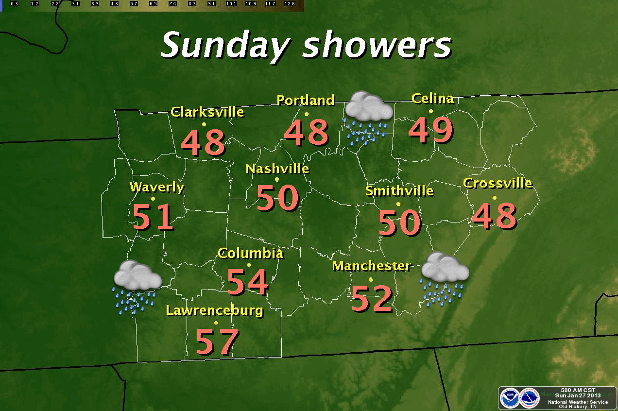
Sunday Rain Chances With Warming Temps


We'll see clouds increase with a 30% chance of rainfall after lunch today. The high will be around 50°, which is about 7 degrees warmer than Saturday's high of 43°. Today's high is tweaked them down a few degrees from yesterday's post. Slight rainfall chances continue this evening with lows by Monday morning of around 41°. We'll be about 10° warmer on Monday afternoon with a high near 60°.

WARMEST DAY IS TUESDAY:
Highs on Tuesday will be 65° under a mostly cloudy sky with thunderstorm chances ramping up to 70% with thunderstorm chances continuing on Wednesday early switching over to showers as the day goes on with highs in the 50's. By Wednesday night we will have a chance (albeit, slight) for the possibility of the rain changing over to snow. We are still several days away so we will watch that and report back as the days get closer.

SHARPLY COLDER AIR THURSDAY AND FRIDAY:
Starting Thursday through the weekend, temperatures will be MUCH colder with highs only in the upper 30's on Thursday. Another blast of cold air for Thursday night and Friday where highs will only be in the low 30's and slightly warmer on Saturday with highs in the low 40's.

*Latest Local Forecast*


Interact with me on social media:
Michael Detwiler on Facebook 
CookevilleWeatherGuy on Facebook
Weather Guy on Twitter
Cookeville Weather Alerts on Twitter
Cookeville Weather Guy on Google +


Saturday, January 26, 2013

Some Sunshine But Chilly For Saturday - Warmer Weather Ahead


We'll begin the process of warming up around the Cookeville area. For today (Saturday), highs will be in the lower 40's with skies becoming partly cloudy and somewhat sunny. We started in the 20's this morning and there are a few slick spots on side streets from yesterday's cold rain and overnight freezing fog. For Saturday night and early Sunday morning, skies will be clear to partly cloudy with a low of 26°.

TEMPS RISE THIS WEEK
The warm up begins in earnest on Sunday with a high into the lower 50's. Rain chances enter the picture for Sunday night (although a low chance - just 30%) and a low of 41°. The slight rain chance continues for both Monday and Monday with temp ranges of 62° down to 49°.

The best day should be Tuesday with a partly cloudy sky and a high of 66°. Thunderstorms become likely on Tuesday night and Wednesday with a low of 52° and a high of 58°. Chilly weather returns for Wednesday night through Friday.

*Latest Local Forecast*

SKYWARN Spotter Training Classes - Open to the public and free. I go about every two years or so to keep my storm spotting skills sharp. Class length is about 2 hours and the material is excellent.

Interact with me on social media:
Michael Detwiler on Facebook 
CookevilleWeatherGuy on Facebook
Weather Guy on Twitter
Cookeville Weather Alerts on Twitter
Cookeville Weather Guy on Google +


Sunday, January 20, 2013

Sunny Sunday with Massive Fall Off Ahead


If you like a little warm weather, get out and enjoy today because you'll not like the next several days as we switch patterns once again. The coldest air YET of the season roars in for Monday night through Wednesday morning.

*Snow and Ice Report for western, middle Tennessee*

Sunday's forecast is for sunny skies and a high of 49°. The winds will switch around to the northwest at around 5 mph but will become calm later in the day. Clear and cold overnight with a low of 27° by Monday morning. Most schools, state, and federal offices will close on Monday (MLK day). Monday's high is expected to be just 38°.

VERY, VERY COLD
Monday night will be mostly cloudy and frigid with a low of 14° by Tuesday morning. As you send the kids out for school, please bundle them up appropriately. Tuesday's high will be just 25° and we'll be bitterly cold once again on Tuesday night with a low of 15° by Wednesday at sunrise. Wednesday's high will warm a bit to 39°.

Further out, we have a slight chance for rain/snow on Thursday and Friday.

*Latest Local Forecast*


Interact with me on social media:
Michael Detwiler on Facebook 
CookevilleWeatherGuy on Facebook
Weather Guy on Twitter
Cookeville Weather Alerts on Twitter
Cookeville Weather Guy on Google +


Tuesday, January 15, 2013

Strange Day But Short-Lived Relief Ahead

Quite the weather day across much of middle Tennessee with freezing rain to our west past Nashville but only rain in much of the rest of the mid-state. The highest accumulation of ice as of 9:30 pm CST is in Dickson and Perry Counties where around 1/4" is being reported. Typically anything under 1/4" is considered a nuisance. Disruptions can occur with 1/2" while widespread accumulations over 1/2" are considered crippling.

Locally in the Cookeville area, it's been an all rain event. If we don't drop by 3-5° tonight, we should remain all rain by the morning. Temperatures should recover nicely on Wednesday with a daytime high of 42° and rain chance of 60%. A slight rain/snow chance on Wednesday night with no accumulation expected and a low of 30°.

Thursday will finally see us drying out but remain cloudy with a high of 44°. Cold and partly cloudy on Thursday night with a low of 26° by sunrise on Friday.

Friday through the weekend is for warm, sunny days on Friday and Saturday with highs in the 50's but backing down to the mid 40's on Sunday.

We completely fall off the cliff with temps on Monday with a high of just 39° and falling temps with scattered flurries and a low of just 12°. Tuesday's high will be just 27°.

*Latest Local Forecast*


Interact with me on social media:
Weather Guy on Facebook
Weather Guy on Twitter
Cookeville Weather Alerts on Twitter


Saturday, January 12, 2013

Overnight Rains Developing - Flash Flood Watch


UPDATE: Friday's high of 70° was just 2° short of the record set in 1916.
Saturday's high is probably going to be 2° short of the record of 70° set in 1932.

Heavy rain will develop overnight across much of middle Tennessee as a strong low-pressure system moves over the area. With the soil already saturated, heavy rains will run off quickly causing streams, creeks, and rivers to rise. Do not cross water that has run over the top of the road. Remember to avoid areas that are prone to flooding.

**FLASH FLOOD WATCH**

Tonight, a 40% chance of showers late (after 3 am) with a low of 59°. South winds gusting to 25 mph.

Temperatures will fall on Sunday after a morning high of around 64° as some storms will produce heavy rains. South winds will be sustained at 15 mph gusting to 25 mph with rain chances 100%.

The rain continues on Sunday night with falling temperatures. We should be around 37° by daybreak on Monday.

We'll keep rain in the forecast on both Monday and Tuesday with highs only in the mid 40's. Expect sunshine on Wednesday with gusty winds and highs again in the 40's. Cold through the weekend with mainly sunny skies during the day and cold nights. Highs in the upper 40's and lows in the low 30's.

A return to winter is forthcoming!

*Latest Local Forecast*


Interact with me on social media:
Michael Detwiler on Facebook 
CookevilleWeatherGuy on Facebook
Weather Guy on Twitter
Cookeville Weather Alerts on Twitter
Cookeville Weather Guy on Google +


AMS

AMS
Member-American Meteorological Society