Showing posts with label heatwave. Show all posts

Sunday, July 8, 2012

Relief Is On The Way


Are you ready for some rain and cooler temperatures? Are your yards, gardens, and farms dry as dirt? I can tell you that relief is coming!

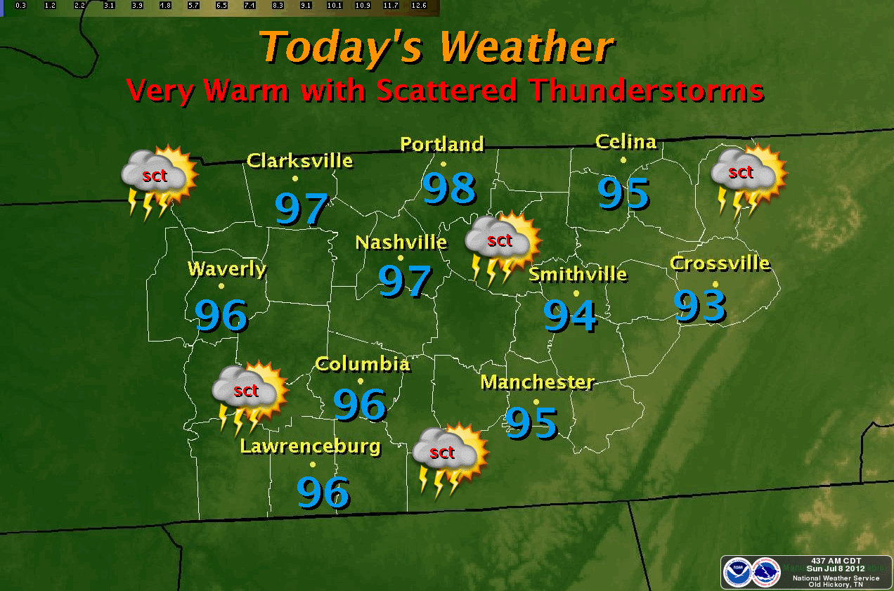
You'll have to bear one more day of oppressive heat as I expect our highs to reach 96-97° range this afternoon. We will NOT break the record high for today (101° from 1988).

Rain chances are increased (at 40%) and will stay that way through Wednesday. The QPF weather forecasting model says we may see up to 2+ inches of rainfall between Sunday night and Monday night. See map below. Click to see a larger map.


Highs on Monday and Tuesday will struggle into the mid 80's with a great chance for thunderstorms as a cold front dives southward.  This will keep a good shot at storms in our forecast for at least 48 hours.

Temperatures will return to more normal like highs (upper 80's) after frontal passage. We'll keep a slight chance of showers in the forecast for late week.

*Latest Local Forecast*

Cookeville's Daily Almanac
July 8, 2012
Yesterday's high: 100.3° (another record high broken from 1930)
*The 7th record high this summer*
This morning's low: 77.1°
Normal: 87/65
Records: 101° in 1988 and 53° in 1918
Last year: 84/69

Rainfall 
0.32 at my station (first rainfall in 3 weeks since June 16th)
July total: 0.32
2012 total: 22.26" - (about 12" behind for 2012)
2.03" of rain fell on this date in 1916


Interact with me on social media:
Weather Guy on Facebook
Weather Guy on Twitter
Cookeville Weather Alerts on Twitter


Saturday, July 7, 2012

Another Hot Day But Relief On The Way


We are already at 87° at 8:30 am in Cookeville, TN. We'll top 100° yet again in Cookeville this afternoon with only a slight chance at a thunderstorm. The record high is 98° from 1930. We'll have an excellent chance to set our 7th record high temperature this summer. We're under a HEAT ADVISORY as heat index readings could near 110°.


Storms rumbled back to our west and southwest yesterday in the later afternoon hours. The high on Friday was 100° breaking the old record of 98° from 1936.


Storm chances increase Sunday and we'll see a bigger increase in coverage and rainfall amounts for Monday night and Tuesday. Some locations will see nearly 2" of rain and we'll cool off by around 15° during the daytime hours.


*Latest Local Forecast*

Cookeville's Daily Almanac
July 6, 2012
Yesterday's high: 100.1° (another record high broken from 1936)
*The 6th record high this summer*
This morning's low: 70.8°
Normal: 87/65
Records: 98° in 1930 and 54° in 1984
Last year: 89/68

Rainfall 
0.00 at my station 
July total: 0.00
2012 total: 21.94" - (about 10" behind for 2012)
4.30" of rain fell on this date in 1979

So far in July, highs have averaged 99.0°


Interact with me on social media:
Weather Guy on Facebook
Weather Guy on Twitter
Cookeville Weather Alerts on Twitter


Friday, July 6, 2012

Heat Advisory Through Saturday Night


The National Weather Service in Nashville has issued a Heat Advisory effective through midnight on Saturday. Temperatures are expected to top 100° on Friday and Saturday with heat index readings around 105°. The record is 98° from 1936. There is an excellent chance we'll set our sixth high temperature record since late June.

DANGEROUS HEAT:
Heat related illnesses such as heat exhaustion or heat stroke are a real threat. Dehydration can occur quickly. The heat will cause drought conditions to slowly worsen and increase the fire danger. As always, take precautions when working outdoors. Those include frequent breaks, wear light colored and loose fitting clothing when possible and drink plenty of water. Be sure to take frequent breaks in shade or if possible, air-conditioned environments indoors. Remember, heat stroke is an emergency - Call 911

Heat Stroke Signs and Symptoms

RAIN AND COOLER TEMPS:
I expect relief to come to the middle Tennessee area in the form of rain and temperatures falling as much as 15° for highs with rain starting Sunday night and continuing through Tuesday. Highs will only reach the mid 80's on both Monday and Tuesday. Some forecasting models peg our total rainfall for that 60 hour period around 1-2". This would be the most rain to fall in a 2-day period since the middle of March.

*Latest Local Forecast*

Cookeville's Daily Almanac
July 6, 2012
Yesterday's high: 99.8° (another record high)
*The 5th record high this summer*
This morning's low: 65.6°
Normal: 87/65
Records: 98° in 1936 and 51° in 1988
Last year: 87/67

Rainfall 
0.00 at my station 
(0.04" at a station east of Cookeville)
July total: 0.00
2012 total: 21.94" - (about 10" behind for 2012)
1.97" of rain fell on this date in 1927


So far in July, highs have averaged 98.5°


Interact with me on social media:
Weather Guy on Facebook
Weather Guy on Twitter
Cookeville Weather Alerts on Twitter

Thursday, July 5, 2012

Hot Once Again


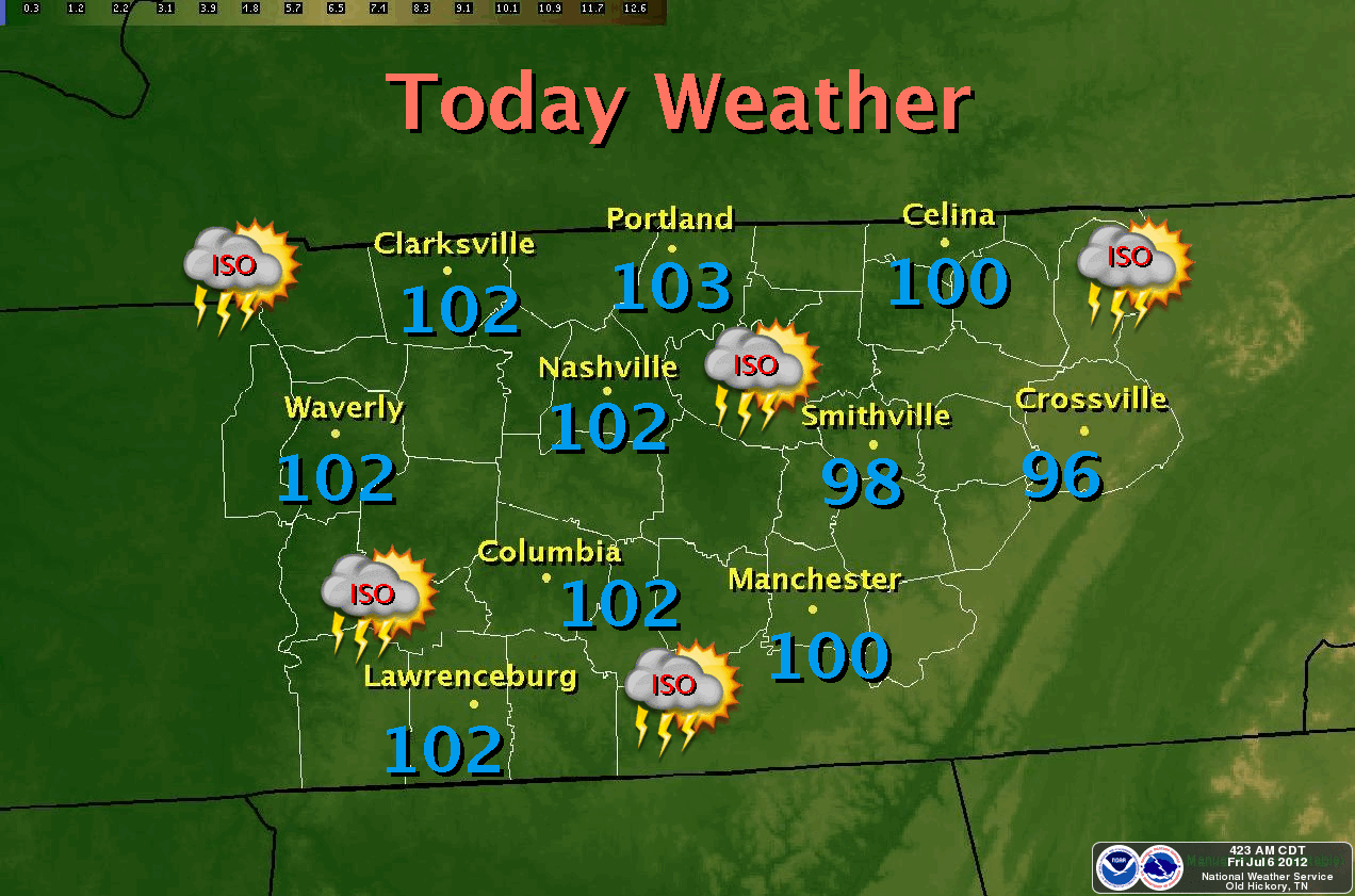
Temperatures will push close to 100° today across the Cookeville, TN area. Back the west near Nashville, they'll easily exceed the 100° mark. A Heat Advisory has been issued for every county west of the plateau. We hit 98° on Wednesday, July 4th.

The good news is we'll continue to keep a chance of thunderstorms in our picture for much of the next 7 days of the forecast. Also, we see a cooling trend starting next week!

At just before 7 am, we're already near 80° in Cookeville.

I would encourage those of you who plan to be outdoors to use caution throughout the day as the heat will be oppressive. Don't become a victim. Drink plenty of water, take frequent breaks, wear light-colored clothing, and stay away from drinks with caffeine or alcohol.

Cookeville's Daily Almanac
July 5, 2012
Yesterday's high: 98.2°
This morning's low: 70.9°
Normal: 87/65
Records: 97° in 1930 and 50° in 1970
Last year: 87/67

Rainfall 
0.00 at my station
July total: 0.00
2012 total: 21.94" - (about 10" behind for 2012)
2.40" of rain fell on this date in 1967

*Latest Local Forecast*


Interact with me on social media:
Weather Guy on Facebook
Weather Guy on Twitter
Cookeville Weather Alerts on Twitter


Wednesday, July 4, 2012

Upper 90's Through The Weekend


Another hot run of weather is forecast for the Upper Cumberland all the way through the weekend. We will stay just below the threshold to issue a heat advisory, but the counties west of Nashville will continue to be under the advisory. I do think we'll see about a 10° drop in highs starting early next week. The big story continues to be the dry weather. Most of the area cannot catch a break in regards to rain.


Over the last couple of evenings I've spent time with growers and farmers who say it is as bad as they've seen it. We stand at less than 30% of normal rainfall since April 1st. For the year, we are more than 10" behind in rainfall. We need a good, slow soaking of rain that a tropical system from the gulf would bring. Unfortunately, there is nothing on the horizon that says the drought will cease.

Your 7-day forecast is below.

*Latest Local Forecast*


Interact with me on social media:
Weather Guy on Facebook
Weather Guy on Twitter
Cookeville Weather Alerts on Twitter


Hot July 4th


Hope everyone is going to have a fun and memorable Independence Day.

HOT AND DRY:
Expect hot temperatures and a slight chance for rainfall. We'll see the upper 90's today. I'll call it 98° with a 20% chance of an isolated thunderstorm. Unfortunately, that means most of us will remain dry. Much of middle Tennessee is between 10" and 15" short on rainfall for 2012.


STAY HYDRATED:
Make sure you stay out of the sun for long periods today and drink plenty of water as the heat can be dangerous. The week ahead will be another hot one. It appears the end of our 7-day just may include some lower temperatures.


FIREWORKS:
A great fireworks show locally in the Cookeville, TN area will occur out in Algood at the City baseball fields. Freedom's Hope (hosted by Trinity Assembly and Church on the Hill) starts at 5:00 pm and the fireworks show starts at 9 pm. Food, drinks, great bands and a great time. Leave your own cooler in your car and your pets at home!

BLAZING HEAT!
Yesterday's high of 98° tied a record. It is the 4th high temperature record set since June 30. It is possible we'll either set or tie the record for today as well.

*Latest Local Forecast*

Cookeville's Daily Almanac
July 4, 2012
Yesterday's high: 98.4°
This morning's low: 71.1°
Normal: 87/65
Records: 97° in 1930 and 51° in 1967
Last year: 87/68

Rainfall 
0.00 at my station (although some received rain)
July total: 0.00
2012 total: 21.94" - (about 10" behind for 2012)
2.43" of rain fell on this date in 1939


Interact with me on social media:
Weather Guy on Facebook
Weather Guy on Twitter
Cookeville Weather Alerts on Twitter


Monday, July 2, 2012

Another Hot Day with Storms Possible Later

We'll be undergoing a bit of a change in the pattern although the highs will push right to 100° once again across the Cookeville area. This could be day #5 in a row. I was amazed by all the haze yesterday while traveling to and from Chattanooga.


BOOMERS AND RAINDROPS:
Did you hear the thunder last night? Did you receive rain? Parts of the Cookeville area did and parts did not. We received a trace of rainfall here last night at MY WEATHER STATION LIVE!

PATTERN CHANGE INCLUDES RAIN:
As promised above, the pattern is changing. We'll still have the heat to contend with but there is an increased chance of showers to start out Independence Day week. I think you can count on a 20-30% chance on Monday, Tuesday, Wednesday, and Thursday. As I stated, it'll still be hot with highs mainly in the mid to upper 90's after today's high near 100°.

SHADES OF COOLER WEATHER AHEAD?
Let's not get too excited BUT there are hints (and I say HINTS) of a possible cool down out in the 10-15 day range. We are still right in the middle of summer so any cool down would be short-lived and not very cool. After temps in the 100's, highs near 90° would be a welcome relief. We'll keep an eye on this possibility.

LIKE the CookevilleWeatherGuy.com on Facebook!

*Latest Local Forecast*


Interact with me on social media:
Weather Guy on Facebook
Weather Guy on Twitter
Cookeville Weather Alerts on Twitter


Saturday, June 30, 2012

Blazing Hot Sunday


Expect the highs on Sunday to top 100° for the 4th day in a row.

We saw the temperature in Cookeville, TN hit 105° on Saturday breaking yet another record. Heat index readings hit 110°. This is a dangerous situation to those who spend a great deal of time outdoors. It is imperative that you stay hydrated during the mid-morning all the way through sunset. By the time you are thirsty, it is too late.

Both Nashville and Crossville broke records again on Saturday.

SUNDAY THRU JULY 4th:
We do expect a similar day to the last two on Sunday with highs easily going over 100°. We'll call it 105°. Over the next 7-days don't expect much in the way of rainfall, but the coolest day of the week will be July 4 (Wednesday) where highs will 'only' reach around 95°. Shower chances increase from 0% on Sunday to around 20% by Wednesday.

*Heat Advisory through 7 pm Sunday*

*Latest Local Forecast*

JUNE 2012 IN REVIEW:
Would you be surprised if I told you June was dry? Just 1.46" of rain and nearly 1/2 of that came on one day (June 5). June's hottest day was Friday, June 29 with a high of 106.1° while the coldest morning was on June 2 at 44.2°. Our maximum wind gust was 22 mph on June 4. 


Interact with me on social media:
Weather Guy on Facebook
CookevilleWeatherGuy.com on Facebook
Weather Guy on Twitter
Cookeville Weather Alerts on Twitter


June 29 Record Heat By The Numbers


As I stated this morning, all time records fell all over the state of Tennessee on Friday as high temperatures were as high as 109°. Here in Cookeville, we tied our all-time heat record with an official reading of 105°, which was set back in 1930


...PUBLIC INFORMATION STATEMENT...

...RECORD HIGH TEMPERATURES ACROSS MIDDLE TENNESSEE...


SITE HIGH JUNE 29 PREVIOUS RECORD/YEAR
CLARKSVILLE 108 106/2007
CHEATHAM DAM 108 105/1980,1983
SHELBYVILLE 108 107/1952
PULASKI 106 105/1980
FRANKLIN 108 108/1930
COLUMBIA 109 109/1952
SMITHVILLE 105 104/1980
KINGSTON SPRINGS 109 108/2007
JAMESTOWN 103 100/2007
CENTERVILLE 105 103/1980
DOVER 108 110/1901
SPARTA 108 104/1980
OLD HICKORY 106 105/2007
COOKEVILLE 105 105/1930
MONTEREY 103 100/1952


OTHER HIGH TEMPERATURES NOT BREAKING THE RECORD.
DICKSON 106 110/1930
LIVINGSTON 106 108/1980


HIGH TEMPERATURE AT SITES WITHOUT RECORDS.
WARTRACE 102
BRENTWOOD 107
CENTER HILL DAM 108
WATERTOWN 109
MONTGOMERY BELL 102
LOBELVILLE 107
MANCHESTER 105
TENNESSEE RIDGE 108
WHITE HOUSE 104
ROCK ISLAND 107
BIRDSONG MARINA 105
CAMDEN 104
CRAB ORCHARD 100
BYRDSTOWN 100
COALMONT 100
HOHENWALD 104
MOUSETAIL LNDG 101
FAIRVIEW 107


Link to records set for Middle Tennessee
At least 18 cities set all-time heat records

*Latest Local Forecast*


Interact with me on social media:
Weather Guy on Facebook
Weather Guy on Twitter
Cookeville Weather Alerts on Twitter


Day 3 of 100+ in Cookeville


The extreme heat wave for middle Tennessee continues today, Saturday, as we expect temperatures to top the 100° mark once again. Much of the area is under a heat advisory and outdoor activities should be limited to the early morning or sunset hours. 


If you must be outdoors for prolonged periods, please take care to increase your water intake and eliminate your alcohol consumption. Heat stroke and heat exhaustion is common during times of extreme heat. Even death has been known to occur. Heat Safety Information

TRIPLE DIGITS AND RECORDS:
After hitting 106° on Friday in Cookeville and seeing numerous records broken across the state, we'll be right back up around that temperature again today. The records, officially, that have been broken so far set June all-time highs and the highest temperatures recorded since records have been kept.

ALL TIME HIGHS:
Nashville 109° (old record 107° on 7-27-52 and 7-28-52)
Crossville 102° (old record 101° on 7-16-80)

TWO MORE RECORDS SET:
Yesterday's all time high in Cookeville was 99°...we are awaiting National Weather Service confirmation on the exact high. Today's all time high is 95°.....that will certainly be broken easily.

Burn bans have been ordered across many counties in middle TN. Locally, all burn permits, for Cookeville have been voided.

*Latest Local Forecast*


Interact with me on social media:
Weather Guy on Facebook
Weather Guy on Twitter
Cookeville Weather Alerts on Twitter


Friday, June 29, 2012

Heat Advisory Through Sunday

Expect highs of 106+ on Saturday. The heat advisory (see below) is in effect through Sunday night.

InteractiveNWS - Alert Information

Record Heat Continues Today Through The Weekend


Sizzling temperatures are on tap for today across the Cookeville, TN area. Expect a high of 105° here in town. That will break a long-standing record. The 100's for highs will continue right through the weekend and into the early part of next week.

We started at 65° at 5:00 am and had climbed to 71° by 7 am. Since the sun is rising, so is the temperature. In just 30 minutes, we gone from 71° to 78°. Going to be a very hot day across Cookeville.

Unfortunately, there is no rain in the forecast through the weekend and probably not even likely until at least next Wednesday or Thursday. Conditions are extremely dry and very dangerous in regards to a fire being easily set and able to spread quickly.

As of now, the professional fireworks show going on in Algood, TN at the Algood ball fields is still on.

*Special Weather Statement*

*Latest Local Forecast*


Interact with me on social media:
Weather Guy on Facebook
Weather Guy on Twitter
Cookeville Weather Alerts on Twitter


Thursday, June 28, 2012

Triple Digit Heat Next 5 Days

Some of the hottest weather in quite some time is poised to set up shop in Middle TN starting today (Thursday) through Tuesday.

In Cookeville we will top 100 today after a comfy morning low of 61.3 degrees. This is dangerous heat so do not over extend yourself outdoors.

At 7 am, it is already 77 degrees.

-Posted with Blogger for Android

Wednesday, June 27, 2012

Heatwave Moves Into Full Swing


After climbing back in the 90's on Wednesday (just a one day reprieve in the 80's Tuesday), we'll push near 100° on Thursday and exceed the 100° mark Friday, Saturday, and Sunday. We may even top 100° on Monday and possibly Tuesday.

Records may well fall on both Friday and Saturday. We'll wait and see how that turns out.

Overnight temperatures in the Cookeville area will fall to near 60° by sunrise on Thursday.

Across the forecast map for middle Tennessee, south central Kentucky, and north Alabama, there are Red Flag Warnings, a Heat Advisory, and Air Quality Alerts near the metro areas. Nearly all of the area is under some sort of Special Weather Statement related to the heat.

Expect temperatures in the Nashville area to push 105° this weekend.

*Latest Local Forecast*


Interact with me on social media:
Weather Guy on Facebook
CookevilleWeatherGuy.com on Facebook
Weather Guy on Twitter
Cookeville Weather Alerts on Twitter


Incredible Heat Ahead

We're poised to be back in the 90's today across the Upper Cumberland region after a one day reprieve. Yesterday's high was just 84° breaking an 8-day streak of 90°+ highs. This morning's low was a very comfy 54.9° at 5:42 am.

WEDNESDAY'S HIGHS:

*Special Weather Statement*


With highs returning to around 90° today it will be the most comfortable day as extreme heat will build across the area beginning on Thursday. I expect our highs to be just under 100° on Thursday, but TOP 100° on Friday, Saturday, and Sunday. Monday and Tuesday should be shade under the 100° mark. 

THURSDAY'S HIGHS:

We'll push records later this week.

Cookeville high temperature records for those days are:
Thursday - 102 in 1936
Friday - 99 in 1936
Saturday - 95 in 1933

I cannot emphasize heat safety enough. Please consult my post on Tuesday evening concerning heat safety tips as well as the Heat: A Major Killer page from the NWS.

*Latest Local Forecast*


Weather News Story of the Day:
The large, out-of-control fire is our story of the day from Colorado Springs. More than 32,000 people have been evacuated as the fire roared toward the gorgeous mountain town that is the home to the Air Force Academy and Dr. James Dobson's organization among others. Pictures from Waldo Canyon fire near Colorado Springs

Interact with me on social media:
Weather Guy on Facebook
Weather Guy on Twitter
Cookeville Weather Alerts on Twitter


Tuesday, June 26, 2012

Record Heatwave Later This Week

After a simply gorgeous day across the region today with highs in many parts of the Upper Cumberland in the lower 80's, we'll be ROASTING over the next several days with possibilities of 100°+ readings especially on Thursday, Friday, and Saturday.

Cookeville high temperature records for those days are:
Thursday - 102 in 1936
Friday - 99 in 1936
Saturday - 95 in 1933

Our best chance for record setting heat will occur both Friday and Saturday.
Not sure we'll hit the record Thursday.


Now is the time to review Heat Safety Information
*Do not be a victim*
*Slow down*
*Drink plenty of water*
*Take frequent breaks if working outdoors especially in direct sunlight*
*Wear light-colored clothing*
*Do not leave a child or pet in the car unattended ever*
*Eat lighter meals*
*Do not drink alcoholic or caffeine-type beverages*
*Spend more time in air-conditioned spaces*

Even if you don't feel thirsty, drink plenty of water. In this heat, when you are thirsty it can be too late. Again, don't be a victim. Take these practical steps above and you'll cope with the heat.


*Latest Local Forecast*


Interact with me on social media:
Weather Guy on Facebook
Weather Guy on Twitter
Cookeville Weather Alerts on Twitter


Nice Tuesday With Another Heatwave Ahead

We're looking at one of the nicer days in quite some time today as highs will only reach the middle 80's today. The nice part is the northeast winds, which will gust to around 20 mph and much lower humidity levels. You'll notice the difference from the 8 straight days in the 90's. Overnight, temperatures will drop quickly and we will end up in the mid 50's by morning.

DON'T GET USED TO IT:
The heat returns on Wednesday with a high of 94°. But that isn't the worst news, there is no rain predicted until at least Saturday. Even then, the chances are remote at best. Temperatures will continue to heat up and I believe we'll push the 100-degree mark on both Thursday and Friday with near 100-degree temps for the weekend.

*Special Weather Statement*


RAINFALL DEFICIT:
We're short on rainfall significantly here in Cookeville. See below for exact #'s
Jan avg. 5.09 Jan 2012: 4.64
Feb. avg. 4.89 Feb 2012: 5.20
March avg. 4.80 Mar 2012: 5.57
April avg. 4.57 April 2012: 2.06
May avg. 5.51 May 2012: 1.98
June avg. 4.62 June 2012: .36

Avg. thru June should be 29.48...currently we sit at 19.81 or nearly 10" below normal. We're about 33% short for 2012. In fact, this quarter we are just 30% of normal or 70% short of average.

As you can tell, we started out great during the first quarter, however this quarter has been brutal in the lack of rainfall and none is expected for the rest of this month.


*Latest Local Forecast*


Interact with me on social media:
Weather Guy on Facebook
Weather Guy on Twitter
Cookeville Weather Alerts on Twitter


Sunday, June 24, 2012

A Very Hot Sunday

Expect middle 90's today across much of the Upper Cumberland region with upper 90's toward the Nashville area. This could be our hottest day of the year in Cookeville. I'll call it 95°. No chance for rain today under sunny skies.

SEE YESTERDAY'S POST ABOUT HEAT SAFETY!

Saturday's high was 92.5° marking the sixth day in a row of 90+ degree weather. The heat index or 'feels like' temperature hit 95°. We had no rainfall and this is the eighth straight dry day. When I mowed my yard on Saturday, I could hear the crunchy sound of dried up grass.

Low tonight will be 67° by Monday morning. We have a slight chance at a thunderstorm on Monday with the approach of a cool front. Temperatures behind the will be quite cool with the Monday night low of 61°. Some areas may even drop into the upper 50's. Tuesday's high will be just 82° and another night back around 60°. After that, the HEATWAVE intensifies with near 100° by the end of next week.

Here is the latest on Tropical Storm Debby. She is slowly moving to the north at 2 mph and is expected to turn west, which is good news for the Florida coast and bad news for the Louisiana and Texas coasts.


TS Debby public advisory

*Latest Local Forecast*


Interact with me on social media:
Weather Guy on Facebook
Weather Guy on Twitter
Cookeville Weather Alerts on Twitter


Saturday, June 23, 2012

Continued Dry And Hot

We'll be right back up in the 90's (92°) again on Saturday with light winds and sunny skies. Clear Saturday night with a low 65° and sunny on Sunday with highs around 95°.

Today will be the sixth straight day of 90+ temps.

Remember, heat is a MAJOR KILLER. Here are some heat safety tips!

There is an Air Quality Alert for the counties surrounding Nashville. This AQA is issued by the Tennessee Department of Environment and Conservation and is called a 'Code Orange'. Ground level ozone levels will approach or exceed unhealthy levels. Generally, the public won't be affected but people with a respiratory disease such as asthma should limit prolonged outdoor exertion.

Lightning Safety Awareness Week starts Sunday! We'll profile some part of safety each day.

*Latest Local Forecast*


Interact with me on social media:
Weather Guy on Facebook
Weather Guy on Twitter
Cookeville Weather Alerts on Twitter


AMS

AMS
Member-American Meteorological Society